

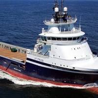
US DOD Awards Contract for At-sea Space Launch Infrastructure
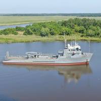
The Spaceport Company (TSC) has been awarded a contract by the Defense Innovation Unit (DIU), an office within the U.S. Department of Defense (DOD), to deliver cargo and enable greater access to space by leveraging a unique, seagoing mobile space launch complex. This prototype is intended to demonstrate delivery to a mission-designed orbit and test autonomy-like features of the sea launch vessel.The ability to rapidly re-constitute space-based capabilities or resupply time-sensitive cargo at precise locations on-orbit or terrestrially is a critical but presently under-developed capability…
SBG Systems' INS Chosen for Shom Fleet
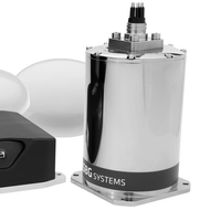
Shom, the French national hydrographic and oceanographic office selected SBG Systems’ inertial navigation sytems to renew their whole fleet of INS. They chose Navsight Apogee INS for their speedboats and survey vessels for both shallow and deep-water real-time bathymetric surveys and Qinertia PPK software for post-processing tasks.Shom has 3 major objectives: national hydrography and cartography, defense support in hydro-oceanographic fields, and support in maritime geospatial products and services for public policies on the sea and the coast.
Smart Navigation System

The research project Prepare Ships, led by RISE Research Institutes of Sweden, will develop a navigation system that foresees the positions of other vessels through machine learning. This reduces the risk of collisions and enables more efficient navigation. The project has recently been granted funding through the “European GNSS Agency”, GSA.A consortium of Swedish, Norwegian and German partners has now been given the go-ahead for their research and innovation project that will increase safety and efficiency in shipping.
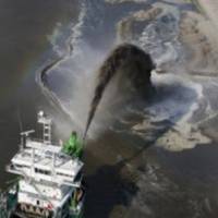
HKND Awards Contract for Survey for Nicaraguan Canal
HKND Group, concessionaire of the Nicaragua Interoceanic Grand Canal project, signed an agreement with international geological and resource consultancy CSA Global of Australia in the headquarters of HKND Group in Hong Kong, entrusting CSA Global to conduct an aerial geological survey of the canal route and Lake Nicaragua shore line. The survey comprises of Aerial mapping of topography, photography and geophysical and geological data. HKND Group concluded an open tender works package award with CSA Global for the services. “The survey is a major step in the construction development process and supports pre-works planning, design and engineering for the canal and infrastructure”, stated senior advisor of HKND Group, John Murray.
C-NAV Upgrades DP Vessel Software
C-Nav, a division of C & C Technologies an Oceaneering International Company providing dynamic DGNSS Precise Point Positioning systems, has introduced a newly upgraded version of its C-Scape software. C-Scape provides independent, real-time monitoring of dynamic positioning (DP) systems, while simultaneously providing operations overview of other vessels infield and subsea infrastructures via multilayer AutoCAD files. C-Scape blends multiple sensor inputs for position quality assurance/quality control and is suitable for most dynamically positioned vessels, including drilling rigs and ships.
Veripos Positioning for MEO Fleet
Singapore-based Miclyn Express Offshore (MEO), a provider of offshore support vessels across Southeast Asia, Australia and the Middle East, has awarded Veripos a five-year contract for provision of high-precision GNSS positioning services in support of its fleet of 27 ships. Under the terms of the contract, Veripos will provide MEO’s fleet with its proprietary Veripos Ultra Precise Point Positioning (PPP) service designed to deliver decimeter-level accuracies globally together with associated integrated mobile receivers. Among the first vessels assigned to utilize the service and equipment are MEO’s new 2,000 dwt platform supply vessels…
C-Nav Launches Tide Measurement Package
C-Nav, a supplier of international GNSS Precise Point Positioning services, announced the launch of its latest GNSS Real-time tide measurement package, C-Tides. The C-Tides suite combines the exceptional vertical accuracy of C-Nav's GNSS Precise Point Positioning service with the latest advanced ocean and coastal tides models. C-Tides Online features real-time filters and vessel dynamics, choice of world-wide Mean Sea Surface or regional reference frame models, and tidal prediction for mission planning, while C-Tides Offline utilities include data smoothing and outlier rejection, harmonic analysis, Doodson X0 filter and a LAT option. www.cnav.com
Latest Tide Measurement Suite Launched by C-Nav
US-based C-Nav Solutions launch its latest GNSS Real-time tide measurement package, C-Tides. The company says that its C-Tides suite combines the exceptional vertical accuracy of C-Nav's GNSS Precise Point Positioning service with the latest advanced ocean and coastal tides models. C-Tides Online features real-time filters and vessel dynamics, choice of world-wide Mean Sea Surface or regional reference frame models, and tidal prediction for mission planning. C-Tides Offline utilities include data smoothing and outlier rejection, harmonic analysis, Doodson X0 filter and a LAT option. C-Tides is a fully supported C-Nav utility. The results are suitable for combining with other suitably calibrated vertical components to achieve IHO SP44 Order 1 or better.
GNSS Positioning: DEME Selects TERRASTAR
DEME, global dredging & land reclamation specialists, select TERRASTAR-D “Precise Point Positioning” service to work with its Septentrio GNSS receivers. The Belgian dredging and environmental group is exploiting the service using Septentrio AsteRx2eL GNSS positioning and AsteRx2eH GNSS heading receivers to support its nearshore dredging and construction operations worldwide. DEME has evaluated and used the service for several months and selected TERRASTAR-D® for its accuracy, stability and consistent performance.
New Allseas Positioning Contract for Veripos
Allseas, a leader in offshore pipeline installation and subsea construction, has awarded Veripos a further three-year contract for continuing provision of specialist GNSS positioning services for its entire fleet of vessels headed by the world's largest pipelaying vessel, the 300m Solitaire. Other vessels concerned include companion DP pipelayers Audacia and Lorelay in addition to the DP trenching support and subsea installation vessel, Calamity Jane, the anchored pipelay barge, Tog Mor, and the ROSVs Highland Fortress, Highland Navigator and Highland Rover. Allseas expect to add to its fleet during the course of the contract what will be the world’s largest construction support vessel…
Offshore Positioning Contract for VERIPOS
VERIPOS, wins a three-year contract from Neptune Marine Services (NMS) of Perth, Western Australia for its GPS augmentation service. The contract, which represents a continuation of a long-standing working relationship between the two companies, covers the provision of VERIPOS’s Standard GPS augmentation service in addition to its Ultra and Apex2 precise point positioning facilities, the latter using both GPS and Glonass constellations. All three services will in turn be supported by VERIPOS’s Verify QC processing software for real-time and post-processing assessments of data. Neptune, one of Australia’s leading subsea engineering organisations, has additional bases in South East Asia, the Middle East and Europe.
Island Offshore Renews Veripos GNSS Positioning Contract
Island Offshore, renews Veripos's 3-year contract for precision GNSS positioning services for DP vessels. Island Offshore awards Veripos a further three-year contract for continuing provision of precision GNSS positioning services for 16 DP vessels in addition to another 6 due to begin service in the near future. The new agreement extends the working arrangement between the two companies which first began in 2007. All the vessels are being supplied with Veripos’s latest Apex2 precise point positioning service using both GPS and Glonass networks as well a combination of its Apex…
Veripos Wins Norwegian Positioning Contract
Aberdeen-based Veripos, a world leader in the provision of GNSS positioning facilities to the offshore oil and gas industry, has been awarded a contract by Dolphin Geophysical AS of Bergen, the newly-formed Norwegian seismic exploration contractor, for the supply of services aboard its recently-commissioned 3D seismic vessel, Polar Duke. The purpose-built flagship vessel, which is currently working on behalf of a major global geoscientific data products and service organisation, is being supplied with Veripos’s Ultra and Apex Precise Point Positioning (PPP) services, each independently ensuring decimetre-level accuracies. Proprietary…
Intermoor GNSS Equipent Order for Veripos
Veripos has received a major order for integrated mobile GNSS receiver equipment from the world’s largest full-service mooring company, InterMoor, an Acteon Company. The equipment, comprising ten Veripos LD3-GI and four LD2-G2 integrated demodulator and GNSS receivers, is being supplied together with upgrades of existing LD2-G1 and LD2-G2 units. Veripos will also provide the Aberdeen-based organization with a full range of GNSS positioning services under an exclusive five-year contract in support of its expanding worldwide activities, which include over 120 annual rig movements in deep to ultra-deep waters. Together with upgraded units…
C-Nav World DGPS Latest QC Package
A new release of C-Nav’s C-Monitor includes a full Quality Control (QC) display feature. The QC solution, specifically tailored to meet the demands of C-Nav’s real-time Precise Point Positioning service, uses a statistically sound RAIM algorithm to detect, identify and eliminate data outliers, then reports the rejection process via NMEA and binary messages. The RAIM algorithm incorporates the latest analytical techniques and is the most comprehensive developed to date. After eliminating outliers, the process performs statistical analysis on the remaining observations using techniques that comply with IMO/NMEA requirements and exceed UKOOA recommendations.
Veripos Extends Positioning Networks
Worldwide GNSS positioning specialist Veripos of Aberdeen has further extended its North American and Far East multi-source regional networks with the establishment of new reference station facilities in Fairbanks, Alaska and Seoul, South Korea. Both stations have been commissioned in response to increased demand from leading operators of 3D seismic and survey vessels and their attendant requirement for seamless fully-redundant positioning support which also provides options for decimeter-level accuracies based on Veripos’ own Precise Point Positioning (PPP) solutions. The regions concerned are expected to see important field development activities in the future involving construction and associated field support vessels.
Veripos Wins Major Offshore Contract
Veripos’ Houston-based Americas Region has been awarded major offshore positioning contracts by , LSP, Tidewater and WesternGeco for vessels operating in Brazilian, Mexican and US waters. The contracts also cover supply of proprietary integrated demodulator and GNSS receivers and associated software modules to ensure seamless high-precision sub-metre positioning for survey, construction support, seismic and general offshore operations. Facilities being provided to LSP for its well-testing vessel, Aires Swan, operating in Mexican waters on long-term contract to PEMEX include Veripos’ dual-beam Standard and Standard HF augmentation data services together with LD2 and LHD2 integrated demodulator and GNSS receivers.


