PortVision: A Helping Hand in the Deepwater Horizon Response

By Raina Clark, from the January edition of MarineNews
MarineNews spoke with Dean Rosenberg, CEO of PortVision, about the company’s role in the coordination of the Deepwater Horizon spill response in the Gulf of Mexico. PortVision is a web-based service that uses data from the Automated Identification System (AIS), mandated by the IMO and the U.S. Coast Guard, to provide shore-side users with real-time vessel tracking as well as historical reporting.
“The main purpose for AIS, why it was mandated, is for collision avoidance,” Rosenberg said. “So if you can imagine a bridge crew of a vessel looking at their navigation gear, able to see all activity going on within a 20 to 30 mile radius … what we’ve done is taken what was mandated legislatively for collision avoidance at sea and built a receiver network on land to allow shore-side users to get other benefits from the technology. These shore-side users, whether it’s a dispatcher, safety officer, scheduler, or a number of different types of users, are getting the benefit of not only the real-time vessel positions, like the bridge crew on the ship, but also the historical information.”
“The PortVision service currently captures over 40 million vessel location reports a day. We maintain a data warehouse of 15 billion records, and then we provide that information back to our subscribers.” That database includes vessel arrivals and departures, vessels passing key points of interest, individual vessel locations and so on. “If a customer is doing training, or if they’re in a commercial dispute, or if they’re looking to analyze waterway activity for best practices, they go into our data warehouse and play back scenarios that have occurred.”
An Integrated Display & Vessels of Opportunity
“For the Deepwater Horizon incident, we provided AIS data to support the responders,” Rosenberg said. “The unified command for the incident was run out of Houma and then there were additional command centers associated with the response. Most of our activity was with the Plaquemines Parish operating branch located in Venice.” Rosenberg said that, associated with the Deepwater Horizon spill response, many different types of government users had access to his company’s system.
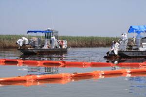
In a press release, Scott Neuhauser, Deputy Branch Director for Plaquemines Parish with BP, said PortVision had significantly improved how vessel activity was managed in relation to the oil spill response and restoration operation. “PortVision has given us significantly greater visibility into what’s occurring in the field so that we could assess progress and more effectively allocate the more than 30,800 personnel, 5,050 vessels and dozens of aircraft that are engaged in the response effort,” he said.
“There were smaller commercial boats that were brought into the response,” Rosenberger said. “They were referred to ‘vessels of opportunity.’ These were the fishing boats and shrimper boats that were called in to assist in some of the clean-up activity. The challenge with a lot of those smaller boats is they don’t meet the standard to require AIS.” Many of these vessels of opportunity were under the length requirement designated by the Coast Guard for mandatory AIS installation. In that case, Rosenberg said, “we have a product called ‘PV-Onboard’ which is a small, battery operated satellite transmitter. When you place that transmitter on the boat, it presents the boat in the integrated display along with all of the AIS targets. It was a way of bringing these smaller boats into a common operational picture of all vessels that were involved in the response.”
“This is really the first time, certainly at this level of magnitude, that private boat operators were brought into a response like this,” Rosenberger said. “I think the term ‘vessels of opportunity’ is apropos. The idea that we could apply commercial, off the shelf solutions to bring those boats into a unified display, along with the big guys, along with the skimmers and the patrol boats and all of the other vessels that were in it for the long haul, is something that I’m not aware has been done before.”
“As you can imagine, things moved very quickly, particularly in the early days of the response. So we did find ourselves moving very quickly to establish new regions where we were detecting AIS.”
Rosenberger pointed to one example that he said spoke to some of the creativity that everyone involved in the response showed. “We were connected with one of the reconnaissance airplanes that was regularly doing flyovers of the area for oil sighting and other logistics activities. So we actually implemented an AIS receiver on board the aircraft. If you can imagine, an aircraft flying several thousand feet in the air has a pretty good blanket ability to receive VHF signals, which are AIS signals. So, as that aircraft was moving it allowed us to ingest additional vessel positions into the system that made it a more dynamic view — even further offshore where our land-based receivers don’t typically receive.”
“The Deepwater Horizon incident hasn’t yet gone into a mode of looking historically at the data,” Rosenberger said. “That will come. If we look at some of the other incidents we’ve been involved in, at some point this will be of value so that when they’re paying claims associated with a boat that was put into service or taken out of service, you’d be able to verify the movements of that boat. You’d be able to see the activities that were performed and correlate that with invoicing or claims or other activities.”
Moving Forward with Business
“There are other systems that show points on a map in real-time,” Rosenberg said. “We weren’t the first company to do that. But we really were the first company to allow users to derive business intelligence from that data.”
“An example would be an oil refinery or marine terminal,” Rosenberg said, “which would gain near-perfect visibility to all ship activity in and around their terminal and be able to better allocate resources.” The refinery or terminal would know when a ship arrives at a sea buoy, the status of pilots or harbor tugs and the location of a tow for tug and barge activity. “Because we were born out of the Gulf of Mexico, we have paying users from almost every major oil company. Those companies are using PortVision for everything from logistic support, dispatch, market intelligence, chartering support, trading support, safety and security applications.”
Rosenberg said a relatively recent practice area for the company is support for legal cases. “We’re involved in about five legal cases every month, just from our clients and their lawyers asking for support around groundings, commercial disputes, collisions, allisions and other sorts of activities that occur, including demurrage related events.”
“One of the ways we provide value is by maintaining an international network of AIS receivers. We currently have coverage in most regions of the U.S. and we’re in about 200 international regions.” Rosenberg noted that the AIS technology that is required by international law, instead of being a burden, has actually been a bonus for maritime business. “Some of our customers comment that this doesn’t happen very often. A lot of times you see new regulations and you get a pit in your stomach. This is one case where those new regulations have driven new efficiencies and new opportunities for the maritime community.”