Cambridge Pixel Enhances RadarView
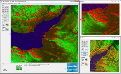
RadarView allows electronic navigation charts (ENC), tiled maps, world vector shoreline, and raster images, to be displayed with the primary radar video.
Cambridge Pixel , a developer of sensor processing and display solutions, has enhanced its RadarView Windows-based radar visualisation software tool to allow complex map and charts, for example, electronic navigation charts (ENC), tiled maps, world vector shoreline, and raster images, to be displayed with the primary radar video.
By adding this capability, RadarView users will be able to not only capture, display and record primary radar and camera video but also to validate and interpret the results based on the map and chart data now available.
David Johnson, managing director, Cambridge Pixel, said: “RadarView is a cost-effective tool for anyone - laboratories, researchers, and other radar end users - that requires a low cost, ready-to-run primary radar display application. In fact, with the map and chart overlay capability providing the context, RadarView could also now be deployed as a basic sensor display system, shipboard radar console or a port display system!
“We see RadarView as a flexible tool that’s a useful addition for any radar user’s armoury – a bit like the oscilloscope is for the electronics test engineer. It can be used to set-up, calibrate, support and maintain a radar display or to record radar data during a mission or research expedition.”
Other enhancements to RadarView include interference suppression - to reduce the display corruption that can occur when similar radars are operated nearby, and adaptive noise removal - to improve the appearance of the radar video by selective removal of background clutter.
RadarView receives, processes and scan converts multiple channels of radar video in normal PPI (plan position indicator) view, and, for more specialist requirements, supports B-Scan and A-Scan formats - the latter is especially useful for radar configuration and set-up.
The ready-to-run RadarView software also allows radar video and camera images to be viewed in multiple windows (up to 5) using standard PC and graphics technology, which allows for considerable flexibility in hosting on low-cost hardware and distributing the radar image remotely using standard Windows capabilities.
“RadarView is already used for a multitude of different applications from ship-based geological research to laboratory-based radar test systems,” added David Johnson. “Kelvin Hughes, for example, uses RadarView as a radar display for set up and maintenance of a shore-based radar system.”
RadarView is part of Cambridge Pixel’s SPx suite of software libraries and applications which provide highly flexible, ready-to-run software products or ‘modules-of-expertise’ for radar visualisation, radar video distribution, plot extraction and target tracking. This provides a powerful set of processing and display components for capture and presentation of radar video using the capabilities of modern multi-core processors and graphics processor units (GPUs).
Cambridge Pixel’s engineering team has decades of experience of developing complex radar processing and display systems for naval, air traffic control, vessel traffic, security and airborne radar applications.


