

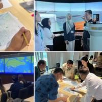
Australia Begins First Live S‑100 Bridge Trial

Australia has commenced its first live shipboard trial of S‑100 digital navigation data, with dynamic tidal and current information now being tested on the bridge of operational cruise vessels in Sydney Harbour.S‑100 is the international standard for next‑generation digital marine navigation, developed by the International Hydrographic Organization. It enables multiple interoperable data layers — such as charts, tides, currents and water levels — to be displayed together on a ship’s bridge…
Report: Many Bridge Teams Struggle with ECDIS Functions

Two years after launching its ECDIS Training Assessment (ETA) platform, NorthStandard draws on cumulative assessment data in a new report which includes key insights on the way shipping can improve ECDIS proficiency on the bridge.Assessments found two-thirds of bridge teams could not identify electronic navigational chart (ENC) updates, and nearly half did not prioritize correct ENC scale in planning. Many also struggled to distinguish alarms from alerts, spot datum issues and verify positions…
Anschütz to Deliver Integrated Bridge System for Arkona Refit

The German Federal Waterways and Shipping Administration (WSV) has awarded Anschütz a contract for the refit of the multi-purpose vessel Arkona, bringing the ship’s navigation and bridge systems up to the latest technological standard.Anschütz will supply a complete SYNAPSIS Integrated Bridge System (IBS) which consolidates all relevant navigation information within a unified and consistent user interface. Radar, ECDIS and conning applications will be provided via multifunctional workstations at all navigation positions…
Industry Bodies Call for Harmonized Propulsion Control Changeover Rules

CIMAC, One Sea, the Nautical Institute and INTERCARGO have jointly called on the International Association of Classification Societies (IACS) to issue a unified interpretation of class rules governing the changeover of propulsion power control (RPM) between the bridge and the engine control room (ECR).The organizations warn that differing interpretations across classification societies and even between individual projects are leading to inconsistent control hierarchies, creating safety risks for operators and crews.
OpenBridge Open-Source Code Library Designed to Boost Shipping Safety

A comprehensive open-source code library has been launched for OpenBridge. This design system is engineered to create safer and more efficient workplaces across the international fleet by standardizing how humans interact with maritime technology.The launch marks the transition of OpenBridge from a design guideline to an open-source ready-to-use code library.OpenBridge is uniquely designed to serve all maritime workplaces. While traditional ship bridge navigation remains a core focus…
Anschütz SYNAPSIS Nav Tech for New Multipurpose Vessel

Anschütz has been awarded the contract to supply Integrated Navigation and Bridge Systems (INBS) for three multipurpose vessels being built for the German Waterways and Shipping Administration (WSV) at the Abeking & Rasmussen shipyard. The first of these, the Scharhörn, has successfully completed a series of sea trials and is nearing delivery.Anschütz equips these ships with SYNAPSIS INBS technology. SYNAPSIS offers a high level of integration and automation, providing the crew with clear and precise information about the maritime environment to support safe navigation…
LEO Satellite Networks: Supporting Maritime Safety, Efficiency and Innovation

Across the maritime sector, the availability of data has never been higher. Supported by new data collection technologies and advanced analytics, mariners are gaining access to increasingly detailed information on the marine environment. Smart sensors are also becoming more widespread, enabling real-time monitoring of on-board equipment and cargo. Combined, these insights have the potential to provide both mariners and shore-based teams with greater situational and operational awareness throughout voyages.However…
Advanced Navigation Raises $110M Series C to Support Increased PNT Technology Demand

Advanced Navigation, a leader in navigation and autonomous systems, announced it has successfully raised $110 million in a Series C funding round. The raise marks a shift in the global autonomy race as national demand for alternative Positioning, Navigation, Timing (PNT) technologies reaches an all-time high.The round was led by Airtree Ventures, with participation from Quadrant Private Equity and the National Reconstruction Fund Corporation (NRFC). These investors join a cohort of existing backers including Main Sequence, KKR, In-Q-Tel, Alpha Intelligence Capital, The Hon.
Anschütz Advances Hunter-Class Frigate Program with Navigation System Design Approval

Anschütz cleared a key milestone on the Royal Australian Navy’s Hunter-class frigate program, successfully completing the Critical Design Review (CDR) for its Warship Integrated Navigation and Bridge Systems (WINBS).The CDR confirms that the system design meets all technical and operational requirements, allowing the program to move into the production and integration phase. For a mission-critical system like WINBS, the milestone provides assurance that the navigation and bridge…
ATSB Releases Preliminary Report on Nuyina Grounding

An ATSB preliminary investigation report details the circumstances leading up to the brief grounding of the Australian research vessel Nuyina off Heard Island, 4,000 km south-west of Perth, October 13 last year.The grounding occurred while Nuyina, the Australian Antarctic Division’s research and supply vessel, was conducting drone survey operations over the shore of Heard Island, close to an area of uncharted seafloor.On board the vessel were 37 marine crew and 85 expeditioners.“Nuyina had several scientific instruments installed on a retractable drop keel…
ATSB Releases Preliminary Report on Coral Adventurer Grounding

An Australian Transport Safety Bureau (ATSB) preliminary report has been released that outlines the order of events leading up to the grounding of the cruise ship Coral Adventurer near a remote port on the north-east coast of Papua New Guinea in December.The ATSB launched a transport safety investigation after the 93-metre Australian-flagged ship grounded on the morning of 27 December 2025, with 80 passengers and 44 crew on board.The cruise, which had left Cairns 10 days earlier, had visited several sites in Papua New Guinea, with passages between them generally conducted overnight.
Gard, NAVTOR Integrate Loss Prevention Insights into NavStation

Marine insurer Gard and maritime technology company NAVTOR have partnered to integrate Gard’s loss prevention content into NAVTOR’s NavStation platform, aiming to improve access to safety guidance for crews and operators at sea.The collaboration enables Gard Insights articles to be delivered directly through NavStation, a digital navigation and voyage planning platform used by thousands of vessels worldwide.The integration places safety and risk management information within the same tools used for operational and voyage planning decisions…
SYNAPSIS integrates AEGIS Combat System

New software module enables seamless, low risk integration between navigation and combat systems Anschütz introduced a major enhancement to its SYNAPSIS integrated navigation platform. A newly developed, defined data interface now connects SYNAPSIS to the Gigabit Ethernet Data Multiplex System (GEDMS), the navigation information distribution network used aboard vessels equipped with the AEGIS Combat System. Developed within the Royal Australian Navy’s Warship Integrated Navigation and Bridge System (WINBS) programme for the Hunter-class frigates in 2025…
Orca AI Launches 360° Field of View

Orca AI has launched the next generation of its AI-based operational platform, delivering a 360° field of view (FOV) around a vessel as a foundation for advanced collision avoidance and autonomous navigation.The 360° FOV configuration is enabled by three SeaPod lookout units, each equipped with high-sensitivity RGB and thermal cameras. Working in unison, they deliver continuous full-perimeter coverage and unified situational awareness around the vessel, enabling detection of overtaking vessels and piracy threats…
Anschütz Delivers SYNAPSIS Integrated Navigation System for First Newbuild Tanker

Anschütz has successfully delivered and commissioned its SYNAPSIS Integrated Navigation System (INS) on the first newbuild tanker constructed for German Tanker Shipping GmbH & Co.KG at Xiamen Shipbuilding Industry Co., Ltd (XSI).TMS Seadevil, handed over in January, is the lead vessel in a program of six modern 41,000 dwt oil and chemical tankers for global deployment and demanding commercial operations. The tankers are designed to support safe navigation in restricted waters, precise maneuvering in ports and terminals and reliable global operations under varying environmental conditions.
NOAA Installs Navigation System in Boston Harbor

NOAA has installed a Physical Oceanographic Real-Time System (PORTS®) in Boston Harbor. The system includes observational equipment at MassPort’s Conley Terminal and on the Tobin Memorial Bridge.The Boston Harbor PORTS, established in partnership with the Massachusetts Department of Environmental Protection, is the 41st installation in a broad, public-private partnership program, providing commercial and other vessel operators with accurate and reliable real-time information about…
IMO Holds First Ship Routing Workshop For Navigation Safety
Government officials and maritime experts from Asian coastal States gathered in Singapore (February 2-6) for the first IMO workshop on ships’ routing and ship reporting systems. The workshop aimed to assist participants in strengthening regional expertise in navigational safety measures, IMO procedures and the effective implementation of ships’ routing and reporting systems, particularly in coastal States experiencing increasing maritime traffic. Ships’ routing is the practice of following predetermined routes for shipping, designed to organize maritime traffic in busy or complex sea areas.
Watchkeepers Could Have Avoided Collision with VHF Communication

The UK Marine Accident Investigation Branch (MAIB) has released its report into the collision between the bulk carrier Polesie and the general cargo ship Verity that resulted in the sinking of the Verity with five fatalities.The collision occurred on the morning of October 24, 2023, when the Isle of Man registered general cargo carrier Verity collided with the Bahamas registered bulk carrier Polesie in the German Bight traffic separation scheme.The investigation found that both…
Report: Tanker Didn’t Stop After Trawler Collision

The UK Marine Accident Investigation Branch (MAIB) has released its investigation report into the collision between the crude oil tanker Apache and the stern trawler Serinah (GH 116) in the Firth of Clyde, Scotland on 25 April 2024.At about 1503 on 25 April 2024, the crude oil tanker Apache and the stern trawler Serinah collided in the Firth of Clyde resulting in Serinah sinking rapidly. All three of the fishing vessel’s crew were able to abandon ship to the liferaft and were uninjured.When the collision happened Serinah was fishing a seabed depression in the middle of the Firth of Clyde…
The Gyrocompass Remains a Powerful Navigation Aid

Anschütz has claimed a new benchmark in naval navigation with its SYNAPSIS WECDIS NX, a system with a powerful mix of navigational and tactical functions.SYNAPSIS brings all navigational and tactical information together into one consistent picture so that navigators interact with a single, harmonised platform.One of the key capabilities of SYNAPSIS WECDIS NX is its robust GNSS interference handling. This is something that Anschütz pioneered with the development of the gyrocompass by Hermann Anschütz-Kaempfe…
Silicon Sensing Expands Distribution in North America

Silicon Sensing Systems Ltd has extended its distribution agreement with Althen Sensors and Controls Inc. in response to a surge in demand, particularly across North America.The new agreement enhances Silicon Sensing’s global distribution network, which stretches across 15 countries. It will help improve customer access to the company’s gyroscopes, accelerometers, and inertial measurement systems and to product integration services. Silicon Sensing’s inertial products are in use in many of the most extreme environments…
Pilot Vessel gets Full Furuno Suite

A comprehensive suite of Furuno navigation and communication systems have been installed aboard Federal Hill, a new Baltimore Class high-speed pilot boat recently delivered to the Association of Maryland Pilots by Gladding-Hearn Shipbuilding.Designed for demanding harbor pilotage in all seasons, Federal Hill relies on Furuno’s NavNet TZtouchXL Multi Function Displays (MFDs) to support safe, efficient operations in congested waterways and challenging conditions. The wheelhouse features dual 16" TZT16X MFDs with a networked DRS6ANXT Solid-State Doppler Radar…
Polar Research Vessel Gets Nav System Refit

Anschütz completed refit of Integrated Navigation System for RRS Sir David AttenboroughSince entering service in 2021, the polar research vessel RRS Sir David Attenborough has been equipped with navigation systems from Anschütz. As part of a recent refit, Anschütz has now supplied the vessel with a new, state-of-the-art SYNAPSIS NX Integrated Navigation System (INS), along with upgrades to the radar systems. The new technology enhances the stability and performance of the bridge system…


