NOAA Commissions Survey Ship

NOAA commissions high-tech coastal mapping 'Ferdinand R. Hassler' in Norfolk, Va. to support NOAA’s nautical charting mission
The new ship’s primary mission will be to detect and monitor changes to the sea floor. Data collected by the ship will be used to update nautical charts, detect potential hazards to navigation, and enhance our understanding of the ever-changing marine environment.
“With the growth in the size of commercial vessels and the importance of waterborne commerce to our economic security, there is a critical need for accurate information about our coastal waterways,” said Kathryn Sullivan, Ph.D., assistant secretary of commerce for environmental observation and prediction. "This advanced NOAA survey vessel will play a vital role in ensuring safe navigation and commerce as we work each and every day to position America for the future.”
Ferdinand R. Hassler will operate mainly along the Atlantic and Gulf coasts, Caribbean Sea and Great Lakes in support of the NOAA Office of Coast Survey ’s nautical charting mission.
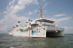
The 124-foot ship will conduct basic hydrographic surveys of the sea floor using side scan and multibeam sonar technologies.
The ship is also equipped to deploy buoys and unmanned submersibles and conduct general oceanographic research. Ferdinand R. Hassler’s twin-hull design is particularly suited to NOAA’s mission to map the ocean floor, as it is more stable than a single-hull vessel.