NOAA, Navy Monitor Ocean Conditions Near Spill
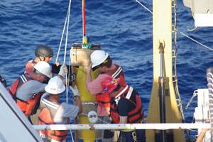
NOAA Ship Thomas Jefferson is underway on a mission to deploy a variety of U.S. Navy ocean monitoring instruments in the vicinity of the BP Deepwater Horizon oil spill. The floats, drifters and autonomous underwater vehicles will aid researchers in monitoring the surface and deep currents that are distributing the oil. Of particular interest is the Loop Current and its potential to spread the oil to a much wider area.
“NOAA is proud to partner with the U.S. Navy in the ongoing effort to provide scientific data critical to understanding the Loop Current and the marine environment in the Deepwater Horizon spill area,” said Jane Lubchenco, Ph.D., under secretary of commerce for oceans and atmosphere and NOAA administrator. “NOAA Ship Thomas Jefferson’s mission will add significantly to the growing body of information NOAA is gathering on the Gulf of Mexico's dynamic environment in collaboration with our federal agency and university partners.”
NOAA Ship Thomas Jefferson was deployed to the Gulf of Mexico in early April to conduct surveys to update the nautical charts and to baseline benthic habitats in the Flower Gardens National Marine Sanctuary. Operated by the NOAA Office of Marine and Aviation Operations, the 208-ft. hydrographic vessel has a crew of 36 NOAA Corps officers, survey technicians and wage mariners. The ship is homeported in Norfolk, Va.
The Naval Oceanographic Office, located at Stennis Space Center in Bay St. Louis, Miss., operates the instrumented drifters, gliders, and floats in support of U.S. Navy operations worldwide. The data collected from these instruments will be shared with the scientific community and used to improve the accuracy of circulation models in the Gulf of Mexico. A NOAA Lockheed WP-3D Orion also has been gathering data on the Loop Current while other NOAA aircraft have been mapping the spill’s extent and surveying marine mammals in the affected area.


