Hurricane Sandy Leaves Fingerprints on Sea Floor

Researchers use side-scan & multi-beam sonar to get a good picture of what the passage of the storm did to the sea bed.
Beneath the 20-foot waves that crested off Delaware's coast during Hurricane Sandy, thrashing waters reshaped the floor of the ocean, churning up fine sand and digging deep ripples into the seabed. Fish, crustaceans and other marine life were blasted with sand as the storm sculpted new surfaces underwater.
University of Delaware (UD) scientists cued up their instruments to document the offshore conditions before, during and after Sandy's arrival to scrutinize the differences and better predict the environmental impact of future storms.
"Out here, we're trying to get the fingerprint of the storm," said Arthur Trembanis, associate professor of geological sciences and oceanography, aboard the research vessel Hugh R. Sharp.
Trembanis and his colleagues focused in on Redbird Reef, an artificial reef about 16 miles off the coast of the Indian River Inlet. The site contains old subway cars, boats and truck tires sunk over the past decade to provide habitat for sea creatures . The scientists have been studying the reef in recent years, among other "hard bottom" sites in this otherwise barren, sandy region, to examine the ecosystem found there and create detailed maps of the seafloor.
Besides improving scientists' understanding of the natural environment, the work has potential military applications: Shifting underwater sands and sediment can bury—or uncover—dangerous mines used to explode enemy vessels in conflict zones . Understanding how weather conditions can affect such objects on the bottom of the ocean could help the Navy, which funded this scientific cruise, identify and avoid the weapons.
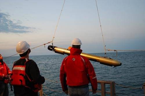
In the peacetime waters off Mid-Atlantic shores, however, the manmade structures at the reef serve as research substitutes for mines. Two days before Hurricane Sandy hit, Trembanis' group set up a specialized buoy at the reef with three different types of equipment attached that rested on the seafloor to measure waves, currents and sand formations on the seafloor.
Side-scan sonar images of Redbird Reef before and after Hurricane Sandy showed wave ripples and exposed mud among the submerged subway cars.
In analyzing the data collected, the scientists will link the geological markings on the seafloor to wave conditions and currents. Then they can develop models of how sediments move and predict whether areas might experience extensive scouring.