C-MAP Appointed Admiralty Distributor
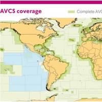
C-MAP has been appointed by the United Kingdom Hydrographic Office (UKHO) as an official ADMIRALTY Digital Distributor and SENC Service Provider. Following this appointment, C-MAP, will now supply ADMIRALTY Vector Chart Service (AVCS), C-MAP ADMIRALTY ENC Service (CAES), ADMIRALTY Digital Publications (ADP) and Electronic Nautical Publications (e-NPs) through its global network of offices and distributors. AVCS - the world’s leading ENC Service - will be provided by C-MAP in both traditional S-63 format and in the time and cost efficient DNV certified SENC data compression format. Named C-MAP ADMIRALTY ENC Service (CAES), the new service is complementary to other C-MAP services including Weather, Piracy and Professional+ (Pro+) chart data.
Danelec Unveils New ECDIS at SMM
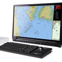
Danelec Marine is rolling out its new DM700 series Electronic Chart Display and Information System (ECDIS) for marine navigation at the SMM maritime trade fair in Hamburg, Germany, held from September 6-9. The DM700 ECDIS provides a basic ECDIS solution that fully complies with the new IEC and IHO performance standards which will be mandatory in all ECDIS ship installations beginning August 2017. Danelec Marine introduced its new-generation DM800 ECDIS in 2015. With the addition of the new DM700…
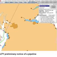
New Danelec ECDIS Includes UK AIO Service
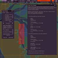
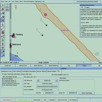
The United Kingdom Hydrographic Office (UKHO) ADMIRALTY Information Overlay (AIO) is now available on Danelec Marine DM800 G2 Electronic Chart Display and Information Systems (ECDIS). AIO allows subscribers using the ADMIRALTY Vector Chart Service (AVCS) to view the latest temporary and preliminary notices to mariners as overlays on the ECDIS screen, as an aid to route planning and navigation. The AIO is displayed as a single layer on top of the basic Electronic Navigation Chart display. “AIO helps bridge crews identify areas of possible uncertainty and risk at the crucial planning stage,” said Thomas Mellor, UKHO head of OEM technical support and digital standards.
UKHO to Release Digital Charts for Expanded Panama Canal

The United Kingdom Hydrographic Office is to release five new Electronic Navigational Charts (ENCs) for the expanded Panama Canal. The new ENCS are produced by the Panama Canal Authority (PCA) and provide end-to-end coverage of the Canal at a scale of 1:10 000. They contain new survey data and up-to-date information for the expanded Canal, which will receive its first official transit on June 26. Jason Scholey, Senior Product Manager at the UKHO, commented: “The Panama Canal serves a vital purpose for international shipping and world trade.
Kongsberg ECDIS Now Includes AIO
The U.K. Hydrographic Office (UKHO) has worked with Kongsberg Maritime to ensure the latest K-Bridge ECDIS and K-Nav ECDIS software includes AIO, making additional chart information available to the mariner when using its Electronic Chart Display and Information System (ECDIS) models. In the past, navigators have relied on the ADMIRALTY T&P NMs to manually update their paper charts. AIO is a free service included with the ADMIRALTY Vector Chart Service (AVCS). The overlay contains worldwide ADMIRALTY Temporary and Preliminary Notices to Mariners (T&P NMs) to be used in conjunction with ENCs.
Danelec Debuts New ECDIS Platform at Nor-Shipping
Danelec Marine announced the introduction of its new Electronic Chart Display and Information System (ECDIS) platform for marine navigation, shown for the first time at the Nor-Shipping 2015 maritime trade fair in Oslo, Norway, this week. Danelec said its new ECDIS platform incorporates new Linux-based application software, an intuitive easy-to-learn user interface, industry-leading cartography solutions, ruggedized low-power LED display monitors and Danelec’s exclusive SoftWare Advanced Protection (SWAP) technology for shipboard service. The new system is designed around a custom-built computer running on Linux, which is more stable, robust and secure than Windows-based PCs. The computer has been designed, tested and built for the marine environment.
Majority of Global Tanker Fleet Yet to Adopt ECDIS
The majority of ships in the global tanker fleet have yet to adopt ECDIS, according to data published for the first time by the United Kingdom Hydrographic Office (UKHO). The SOLAS regulations on the mandatory carriage of ECDIS will come into force from July 1, 2015 for all tankers over 3,000 gross metric tons, apart from permitted exemptions. Over 8,500 tankers will be required to comply with these rules and, with less than 10 months to go, the UKHO can reveal that 58% of these ships do not yet use an ENC service.
Northrop Grumman Enhances VMFT Software
Northrop Grumman Corporation announced that its latest VisionMaster FT (VMFT) software now includes ADMIRALTY Information Overlay (AIO) as an integral element of its Electronic Chart Display and Information System (ECDIS) based navigation system making additional chart information available to ship’s navigators. In the past, navigators have relied on the ADMIRALTY Temporary and Preliminary Notices to Mariners (T&P NMs) to manually update their paper charts. AIO is a free service included with the ADMIRALTY Vector Chart Service (AVCS).
Commercial Marine World on Show at Seawork

From countries across the globe, including Australia, Canada, the U.S. and Europe, more than 500 exhibitors will be at Seawork International, the commercial marine exhibition and conference, opening on Tuesday, June 10 for its annual three-day run in the ABP Port of Southampton, U.K. More than 7,000 visitors are expected to attend Seawork, which will feature products and services relevant to every sector of the commercial marine industry, including offshore wind farm construction and maintenance…
UKHO Launches New Routing Charts
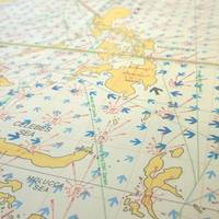
The United Kingdom Hydrographic Office is launching a new large-scale routing chart covering the busy shipping waters of Vietnam, Indonesia and the Malacca Strait. Routing Chart 5141 is the latest addition to the UKHO's routing chart series and will be published on February 27, 2014. As well as covering a very busy shipping area, Routing Chart 5141 has been compiled in a larger scale than the UKHO's existing routing charts and features more detailed and up-to-date meteorological and currents information.
Transas Launches Updated Navi-Planner
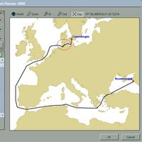
The updated version of the globally renowned voyage planning software Navi-Planner 4000 received additional functions, boosting versatility and convenience. The Transas Navi-Planner 4000 software is recognized as one of the ECDIS market’s most powerful charts and data management tools, and also boasts a set of databases, applications and services intended for every step of voyage planning. In addition to working with the Transas Admiralty Data Service (TADS), the new version of the Transas Navi-Planner is now optimized to handle ADMIRALTY Vector Chart Service (AVCS) charts and permits.
Why Seall Passage Planner Deserves Attention
Advanced technology enriches our lives in many different ways and it also relatively and closely affects the maritime industry. Since the IMO (International Maritime Organization)’s announcements about the regulations of ECDIS (Electronic Chart Display and Information System), the challenges in marine software development have become more competitive and dynamic. “Every development project starts with questions such as 'what,' 'why' and 'how.' At Jargoon we aim to provide high quality solutions to our clients, with the most innovative features and functions.
Totem ECDIS Now AIO Compatible
Totem Plus, manufacturer of Automation and Navigation systems, announced that Totem ECDIS is now compatible with the ADMIRALTY Information Overlay (AIO). Type approved by DNV, Totem ECDIS provides real-world innovation to the customer. It was the world’s first ECDIS to provide Collision Avoidance in the form of Decision Support Tools; it initiated the ‘Shift Change’ procedure to avoid ECDIS-assisted accidents; and is now also compatible with AIO, provided by the United Kingdom Hydrographic Office (UKHO).
Korea Lines Upgrades Navigation Package

Thomas Gunn is delighted to announce that Korea Lines, the marine transportation services company, is the latest ship owner to choose new Voyager 4 for its navigation requirements. It will be upgrading four LNG gas carriers from Voyager 3 to the new Voyager 4 digital chart management system with immediate effect. When asked why Korea Lines selected Voyager 4, Mr Cho Han-Ung, Principal Superintendent, Fleet Management Team 2 explained, “We needed a navigation solution which would best serve the needs of the internationally trading vessels operating within our fleet.
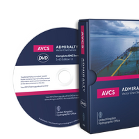
Admiralty Vector Chart Service Now Available on DVD
The United Kingdom Hydrographic Office (UKHO) unveiled plans to supply the Admiralty Vector Chart Service (AVCS) on one DVD from summer 2013, providing customers with a range of benefits, including faster loading speeds, reduced data handling and fewer warning messages. Combined with the existing online ENC updating service and custom exchange set option delivered through e-Navigator Planning Station, AVCS on one DVD marks a significant step forward in making open, S-63 based ENC services much easier for the mariner.
South China Sea Digital Chart Coverage Complete
The United Kingdom Hydrographic Office (UKHO) has added two digital charts of the South China Sea to its ADMIRALTY Vector Chart Service (AVCS) to complete the coverage. The cover is now complete for shipping routes from Singapore to China and beyond. Jason Scholey, Senior Product Manager - Charts, commented: “We are delighted to announce the inclusion of these two charts to AVCS. This continues to ensure that our customers have the most comprehensive global maritime ENC service…
JRC ECDIS Models Update with Admiralty Info. Overlay
A software update now makes the Admiralty Information overlay available on all current JRC ECDIS models. The Admiralty Information Overlay, a free service to Admiralty Vector Chart Service customers, is a simple way to view the most comprehensive and up-to-date chart information when navigating with electronic navigational charts (ENCs). The Overlay is the only service available to include worldwide Admiralty Temporary and Preliminary Notices to Mariners and new ENC Preliminary Notices to Mariners, which identify navigationally significant differences between ENCs and Admiralty paper charts. Mariners the world over rely on Admiralty updates to help them navigate safely, via the weekly ‘Notices to Mariners’ publication, which is used to manually update paper charts.
Admiralty Provides New ENC Coverage of Vietnam
The United Kingdom Hydrographic Office (UKHO) has announced new ENC (Electronic Navigational Chart) coverage of a key shipping route in Vietnam, providing greater navigational detail of the region. The three new ENCs cover the ports and approaches to Vung Tau, which includes the main container port of Cai Mep, and are only available through the Admiralty Vector Chart Service. The new ENCs have been produced in response to increasing demand from shipping companies for fully compliant chart data for the region, which has seen significant economic development in the last decade. “Vietnam continues to outperform many economies around the world,” said Guy Edwards, Head of Admiralty Asia Pacific, Singapore.
UKHO at Nor-Shipping 2011
The UKHO today announced its attendance at Nor-Shipping 2011 will offer shipping managers both practical guidance and strategic insight to help them effectively plan for the successful adoption of digital navigation. In addition to the main Admiralty stand (Hall B, B0-14) the UKHO is hosting a series of unique daily seminars and workshops which explore the immediate operational challenges and future strategic decisions faced by shipping managers. From Tuesday to Thursday, the seminar programme leads with an inspirational presentation from futurologist Dean van Leeuwen, entitled ‘TIDES of Change.’ ‘TIDES of Change’ – which debuted at Sea Asia in April 2011 – provides some thought-provoking material on the evolving world of technology and business…
UKHO Updates Digital Navigation
The UKHO today announced another simple way to view the most accurate and up-to-date navigational charts, with the release of SevenCs ORCA Master Electronic Chart System (ECS) compatible with the Admiralty Information Overlay. The Overlay, brings the latest navigational updates from Admiralty to an ECDIS or ECS to help make digital navigation safer, more efficient and fully compliant. Available from Admiralty, the Overlay is now compatible with both Transas and SevenCs systems. Transas was the first to announce availability via the Transas Admiralty Data Service (TADS), and the UKHO is also working with other major ECDIS manufacturers to ensure the Admiralty Information Overlay can be displayed on their systems. Further availability will be announced in the next few months.
Commander-in-Chief Fleet Visits Ukho
The Royal Navy’s leading Operational Commander visited the United Kingdom Hydrographic Office (UKHO) Friday, March 27, to see the navigational services and charts that the organisation provides at first hand. The Commander-in-Chief Fleet (CINCFLEET), Admiral Sir Mark Stanhope KCB OBE, is responsible for delivering the Fleet Operational Capability. This includes the operation, resourcing and training of the Royal Navy’s ships, submarines and aircraft, and personnel including the Royal Marines.