

Theyr Debuts Weather, Ocean Forecasting App
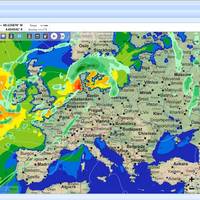
Theyr Ltd, a premium weather-forecasting provider, specializing in the maritime and wind energy sectors, announced today the launch of its Digital Precision Weather and Ocean Forecasting app for the professional mariner, GRIBview mobile. The revolutionary App delivers a level of weather and ocean forecasting accuracy previously unseen in the mobile market. GRIBview mobile provides free and unlimited GRIB downloads for GFS (Global Forecasting System) data at 1-degree resolution, as well as unlimited High-resolution data down to 1km resolution for exceptional accuracy. In addition, subscriptions to high-resolution premium weather data packages include wind speed, barometric pressure, precipitation, air temperature, sea surface temperature, significant wave height, period and direction.
Northport Systems Upgrades Navigation Softwre
Software developer Northport Systems Inc. has announced the latest enhancement to its innovative Fugawi Marine 5 marine navigation software, Theyr Weather. Fugawi Marine 5 allows for simple download, management, and display of high-resolution weather data from the X-Traverse web service, eliminating the need to sift through low quality GRIB files from multiple, hard-to-find sources. Whether planning a multiday journey or trying to spot the biggest wave, Theyr’s GRIB data keeps boaters informed of the weather conditions most relevant to their on-the-water excursions.
Navionics Chart Support Added to iPhone
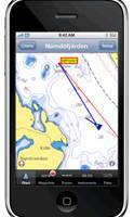
Software manufacturer Northport Systems Inc. announced that its popular Fugawi X-Traverse online map collection for use with iNavX marine software for the Apple iPhone now supports Navionics marine and outdoor charts. Adding to iNavX’s support of raster maps including NOAA RNC, Swedish Marine Charts, and TRAK Maps, users now have subscription-based, fingertip access to world-wide Navionics Gold+ international marine, HotMaps Premium North American fishing and European Discovery outdoor charts from www.X-Traverse.com. Navionics charts are downloaded directly into iNavX software through the iPhone’s internet connection (Edge, 3G or WiFi) and saved locally on the phone for use when outside of cell phone or WiFi internet coverage.
Fugawi X-Traverse Supports Online Charts
Software manufacturer Northport Systems Inc. announced the addition of Hilton’s Realtime-Navigator support to its online Fugawi X-Traverse collection for use with Fugawi navigation software, Apple iPhone and MacENC for Apple OS X. The combination of Fugawi X-Traverse and Hilton’s Realtime-Navigator gives users an unparalleled set of ocean condition tools to identify fish holding locations. The ultimate saltwater fishing tool, Fugawi X-Traverse provides users of the iPhone, PCs or Macs with the most up-to-date water condition detail. Hilton’s Realtime-Navigator provides boaters with unlimited access to the latest sea surface temperature…
Fugawi Swedish Marine Charts
Software manufacturer Northport Systems Inc. announced the addition of Swedish Marine Charts to its online Fugawi Touratel Map collection for use with Fugawi navigation software and the Apple iPhone. The X-Traverse chart and map data distribution system is also now available for integration by third-party developers who wish to easily add marine charts and land maps to their mobile applications. Compatible with Fugawi Marine ENC and Fugawi Global Navigator navigation software for PC…


