

Navionics charts in iNavX In-App Chart Store Available
iNavX, the benchmark marine navigation mobile application, announced today, in partnership with Fugawi and Navionics, the availability of Navionics charts in the iNavX In-App Chart Store. This is a first for the industry, and iNavX is the only independent marine navigation app to offer Navionics charts to its users. “When it comes to crucial navigation information, boaters’ decisions about what apps, electronics and charts they use can be as varied and personal as the foul weather gear they wear to keep them dry,” said Shaun Steingold, CEO, NavX Studios. “The most respected name in electronic charting and cartography is Navionics and…
iNavX Debuts IN-APP Charts, Maps Purchase Capability
iNavX, the benchmark marine navigation mobile application, in partnership with Fugawi X-Traverse, today launched its chart and map in-app purchase program. Now enabled with one-touch purchase and download, iNavX gives boaters the most streamlined access to the broadest set of marine charts and maps from multiple providers. iNavX users will gain intuitive download capabilities for all of their favorite chartsand navigation data such as Navionics’ worldwide chart catalog, Canadian Hydrographic Service (CHS) charts; Fugawi Aboard quilted Canadian and US charts; NV Charts for Europe, the US and the Caribbean; Theyr weather; Waterway Guide…
Rushton Gregory Inks iNavX Marketing Deal
Rushton Gregory Communications, a marketing communications agency specializing in the marine, outdoor, automotive and consumer electronics markets, announced today the latest addition to its industry-leading client roster, NavX Studios. Based in San Francisco, NavX Studios recently acquired iNavX, a pioneering mobile Marine navigation application. iNavX is developed specifically for mobile devices running iOS. With the iNavX app, users can purchase and display charts and navigation data from a number of the industry’s leading providers including Explorer, Navionics, NOAA, Theyr and X-Traverse. Under the terms of the partnership, Rushton Gregory will drive NavX Studios’ public relations efforts for iNavX including announcing new offerings…
Theyr Debuts Weather, Ocean Forecasting App
Theyr Ltd, a premium weather-forecasting provider, specializing in the maritime and wind energy sectors, announced today the launch of its Digital Precision Weather and Ocean Forecasting app for the professional mariner, GRIBview mobile. The revolutionary App delivers a level of weather and ocean forecasting accuracy previously unseen in the mobile market. GRIBview mobile provides free and unlimited GRIB downloads for GFS (Global Forecasting System) data at 1-degree resolution, as well as unlimited High-resolution data down to 1km resolution for exceptional accuracy. In addition, subscriptions to high-resolution premium weather data packages include wind speed, barometric pressure, precipitation, air temperature, sea surface temperature, significant wave height, period and direction.
Fugawi Debuts Quilted Charts
Industry leading online chart service Fugawi X-Traverse, announced today that in coordination with GPSNavXTM and its app, iNavX, the availability of quilted raster charts for the navigation app’s most recent version. One of the most established marine navigation apps on the Apple iOS platform, iNavX brings the latest marine navigation features to iPhone and iPad users. In an exciting revision of the top-selling app, iNavX adds greater functionality to its already robust feature set. Offering users the ability to plot position in real-time on multi-touch marine charts with scroll, zoom and rotate, the app can also act as a repeater for popular marine navigation software that supports NMEA data over TCP/IP. They weather forecasts; and even an anchor alarm.
Northport Systems Upgrades Navigation Softwre
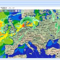
Software developer Northport Systems Inc. has announced the latest enhancement to its innovative Fugawi Marine 5 marine navigation software, Theyr Weather. Fugawi Marine 5 allows for simple download, management, and display of high-resolution weather data from the X-Traverse web service, eliminating the need to sift through low quality GRIB files from multiple, hard-to-find sources. Whether planning a multiday journey or trying to spot the biggest wave, Theyr’s GRIB data keeps boaters informed of the weather conditions most relevant to their on-the-water excursions.
Simrad Yacthing Offers Wireless Networking Solution
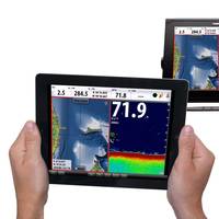
Simrad Yachting announced the availability of its wireless networking solution, GoFree Wireless. Combining user-friendly mobile software and rugged marine-grade hardware, the GoFree Wireless solution consists of the GoFree Viewer and Control App, and the Simrad WIFI-1 wireless gateway. Enabling wireless connectivity between Simrad NSS Multifunction Displays (MFD) and tablets, mobile phones and computers, GoFree Wireless offers boaters an exciting new level of navigational control.
Fugawi X-Traverse Compatible with the iPad
Software manufacturer Northport Systems Inc. announced that its Fugawi X-Traverse online map collection is now compatible with the iNavX Version 3 app for the Apple iPad. The new Fugawi X-Traverse functionality offers boaters and outdoor enthusiasts the power of a mobile color chartplotter at a fraction of the cost. Guaranteeing the most-up-to-date cartography available, Fugawi X-Traverse iPad support provides users with fast, high-detail chart viewing on the brilliant, 9.7-inch, 1024 x 748 pixel iPad screen, integral Global Positioning System (GPS) capabilities, and seamless multi-touch scrolling and zooming of chart detail. iNavX also provides support for AIS and NMEA instrument integration. www.fugawi.com www.x-traverse.com
Navionics Chart Support Added to iPhone
Software manufacturer Northport Systems Inc. announced that its popular Fugawi X-Traverse online map collection for use with iNavX marine software for the Apple iPhone now supports Navionics marine and outdoor charts. Adding to iNavX’s support of raster maps including NOAA RNC, Swedish Marine Charts, and TRAK Maps, users now have subscription-based, fingertip access to world-wide Navionics Gold+ international marine, HotMaps Premium North American fishing and European Discovery outdoor charts from www.X-Traverse.com. Navionics charts are downloaded directly into iNavX software through the iPhone’s internet connection (Edge, 3G or WiFi) and saved locally on the phone for use when outside of cell phone or WiFi internet coverage.
Fugawi X-Traverse Supports Online Charts
Software manufacturer Northport Systems Inc. announced the addition of Hilton’s Realtime-Navigator support to its online Fugawi X-Traverse collection for use with Fugawi navigation software, Apple iPhone and MacENC for Apple OS X. The combination of Fugawi X-Traverse and Hilton’s Realtime-Navigator gives users an unparalleled set of ocean condition tools to identify fish holding locations. The ultimate saltwater fishing tool, Fugawi X-Traverse provides users of the iPhone, PCs or Macs with the most up-to-date water condition detail. Hilton’s Realtime-Navigator provides boaters with unlimited access to the latest sea surface temperature…
Fugawi Swedish Marine Charts
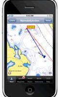
Software manufacturer Northport Systems Inc. announced the addition of Swedish Marine Charts to its online Fugawi Touratel Map collection for use with Fugawi navigation software and the Apple iPhone. The X-Traverse chart and map data distribution system is also now available for integration by third-party developers who wish to easily add marine charts and land maps to their mobile applications. Compatible with Fugawi Marine ENC and Fugawi Global Navigator navigation software for PC…




