

Keel Laid for NOAA Charting and Mapping Vessel
A keel-laying ceremony has been held for Surveyor, a new charting and mapping vessel being constructed for NOAA by Thoma-Sea Marine Constructors, LLC., in Houma, Louisiana.In 2023, NOAA announced two new charting and mapping vessels would be added to its fleet. Surveyor is expected to be completed in 2027 and Navigator in 2028. The ships will be used primarily for ocean mapping and nautical charting as part of NOAA’s mission to deliver tools and information to help mariners safely…
IHO Nautical Information Provision Work Group endorses Guide for Nautical Data 2.1
During a meeting on 4 December 2024, the International Hydrographic Organization Nautical Information Provision Work Group (IHO NIPWG) held a vote on the new Guide for Nautical Data 2.1. The guide was unanimously endorsed.The guide has been written, with contributory input from International Harbour Masters Association (IHMA) members around the world, to support hydrographic offices and port authorities in the discharge of their collective responsibilities as per the International Maritime Organization’s (IMO) International Convention for the Safety of Life at Sea (SOLAS) Chapter V…
China: US-backed Philippines 'provoked trouble' in South China Sea
China accused the Philippines on Friday of having "provoked trouble" in the South China Sea with U.S. backing, a week after Beijing and Manila traded accusations over a new confrontation in the disputed waters."The Philippine side, with U.S. support and solicitation, has been stirring up trouble in many spots in the South China Sea," Wu Qian, a spokesperson for China's defence ministry, said on its official WeChat account."The Philippines is well aware that the scope of its territory is determined by a series of international treaties and has never included China's" Spratly Islands and Scarborough Shoal, he added. Beijing and Manila have been involved this year in a series of confrontations at reefs and outcrops in the South China Sea…
Philippines and China Dispute Over South China Sea Incident Escalates

China and the Philippines gave conflicting versions on Wednesday of a maritime confrontation around a contested shoal in the South China Sea, the latest row in a longstanding dispute between the neighbours.Chinese coast guard vessels fired water cannons and side-swiped a Manila fisheries bureau boat on the way to deliver supplies to Filipino fishermen in the area, according to Philippines officials, a move that drew condemnation from the United States.The incident follows a diplomatic…
Satellite-based Solution Helps to Prevent Ship Groundings in Coastal Waters
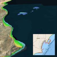
Recent incidents of naval and commercial vessels running aground have underscored the inherent risks of operating in shallow and poorly charted coastal waters. A solution from Denver-based TCarta Marine utilizes Earth observation satellites to deliver precise water depth measurements in near-shore areas.“While the exact causes of recent ship groundings off the coasts of Oman, Greenland, and Fiji are under investigation and often complex, the risk of such accidents can be significantly reduced with up-to-date bathymetric data produced from satellite imagery…
NOAA Reveals Names of its New Mapping Vessels

The National Oceanic and Atmospheric Administration (NOAA) has revealed the names of two new charting and mapping vessels it ordered from Thoma-Sea Marine Constructors in 2023.The names Surveyor and Navigator were chosen from a list of suggestions by NOAA staff, adhering to the agency’s naming policy that emphasizes vessels named for their missions.The name Surveyor holds significant historical weight. It not only pays homage to NOAA's mission but also honors two previous vessels that bore the same name.
Bulk Carrier Grounded Due to Inadequate Clearance Guidance
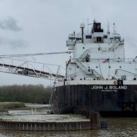
Inadequate operating company guidance on underkeel clearance led to the April 2023 grounding of a bulk carrier in Lake Huron, the National Transportation Safety Board (NTSB) said Tuesday.The 667-foot-long, self-unloading bulk carrier John J Boland—owned by American Steamship Company and operated by Grand River Navigation under charter—grounded twice as it was completing final loading in Port Dolomite, Michigan on April 21, 2023. The crew discovered flooding and damage to the hull after it was underway.
Report: Submerged Rock Led to Fishing Vessel Grounding
A captain’s decision to navigate close to shore in an area with uncharted rocks led to the grounding and capsizing of a fishing vessel in Alaska last year, the National Transportation Safety Board (NTSB) said.The Challenger struck a submerged rock while fishing for salmon along the shore of Kodiak Island, Alaska on August 7, 2022. The vessel began taking on more water than the onboard pumps could handle. The captain and three crewmembers abandoned ship and were rescued by a nearby Good Samaritan fishing vessel, and the vessel capsized soon after.
Navigational Errors Caused Cruise Ship to Strike Pier in Alaska
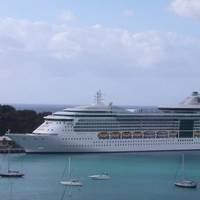
Overreliance on an electronic chart, miscommunication and an outdated navigational chart were among factors that led to a cruise ship striking a pier last year near Sitka, Alaska, the National Transportation Safety Board (NTSB) said Tuesday.The Royal Caribbean cruise ship Radiance of the Seas was docking at the Sitka Sound Cruise Terminal on May 9, 2022, when it struck and damaged a mooring dolphin. The cruise ship sustained a minor hull indentation. The mooring dolphin sustained damage to three of the four pilings supporting it.
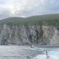
Spanish Navy Ship Sent to Draw Up Maps Loses Its Way
A Spanish Navy ship tasked with updating nautical charts to make navigation safer got stranded on Thursday near the island of Ibiza in the Mediterranean, the Navy said.The vessel Malaspina was exploring an area of shallows to the west of the island and got stuck on one of them. Rescue teams have been sent to help remove the vessel from the ground, the Navy said in a statement."After an initial inspection... no structural damage can be seen," it said.
Floating Offshore Wind: New Seascape, New Challenges
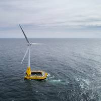
Offshore wind energy planners are giving close review to fixed-tower systems in order to extend lessons learned to floating wind towers, under development now. In the U.S., floating towers have been most closely associated with plans for new wind energy areas (WEA) in the Pacific, off of California and maybe Oregon and Washington. But important research is also taking place in Maine, at the University of Maine, because of deep ocean Atlantic areas there, and floating towers may also be used in the Gulf of Mexico.As most readers likely know…
Teledyne Acquires ChartWorld International

Teledyne Technologies Incorporated announced today that it has acquired ChartWorld International Limited and affiliates. ChartWorld, headquartered in Cyprus, with additional locations in Hamburg, Singapore, Vancouver and Tokyo, is a provider of digital marine navigation hardware and software provided through a subscription-based model. Terms of the transactions were not disclosed.Commercial maritime subscribers to ChartWorld’s software as a service (SaaS) receive free type-approved Electronic Chart Display and Information Systems (ECDIS), a lifetime warranty and global 24/7 support.
UKHO Launches ADMIRALTY Small Craft Charts Service
The UK Hydrographic Office (UKHO) has launched its ADMIRALTY Small Craft Charts service - formerly known as ADMIRALTY Leisure Chart Folios – to bring important safety, quality and flexibility benefits to all marine users who depend on these charts.The launch of this new service follows the announcement in May 2021 that UKHO will withdraw the regional folio structure for these charts. Instead users can purchase only those charts that are relevant to their needs without being required to purchase the full regional folio.Through this updated product…
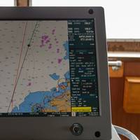
Electronic Navigational Charts: An Update and Some Issues
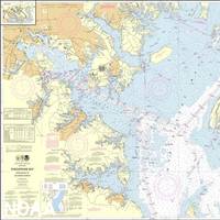
In November 2019, the Office of Coast Survey (OCS), part of the National Oceanic and Atmospheric Administration (NOAA), announced the start of a five-year program to “sunset” all raster and paper nautical charts.NOAA has produced electronic navigational charts (ENCs) since 1993. In the 2019 notice, NOAA writes that “ENC sales increased 425% since 2008, while sales of paper charts are now half of 2008 levels.”For NOAA and mariners, a focus on electronic charts and publications promises many advantages. With a singular focus, NOAA can use its resources more efficiently.
NOAA Continues Transition to Electronic Navigational Charts
NOAA is continuing with the sunset plan for paper and raster nautical charts in August and September. A set of 15 charts covering the eastern half of the North Slope of Alaska will be moved into last edition status on August 5, 2021 and will be canceled on February 2, 2022. Another set of 14 charts covering the western half of the North Slope will be moved into last edition status on September 2, 2021 and be cancelled on March 2, 2022.This set of charts has been fully supplanted by new electronic charts as part of NOAA’s Office of Coast Survey Raster Sunset Plan…
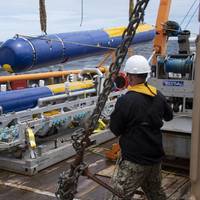
Need a Survey? There’s a USV for That
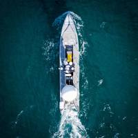
While the adoption of unmanned/uncrewed surfaces vessels (USVs) was initially in defence, use of these low footprint systems has spread into other sectors, not least survey, and now the race is on for greater capability, endurance and autonomy. Elaine Maslin reports.After starting small, in inland waterways, use of USVs for survey operations has moved into coastal and now offshore waters. Given the extensive amount of seabed and rapid growth in offshore wind, there’s plenty of work out there for them to do.With the travel restrictions posed by Covid and increasing awareness of climate change…
NOAA Begins Transition Exclusively to Electronic Navigation Charts
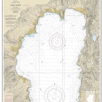
NOAA will begin to implement its sunset plan for paper nautical charts this month, starting with the current paper chart 18665 of Lake Tahoe. After August, NOAA’s electronic navigational chart will be the only NOAA nautical chart of the area.This is the first traditional paper chart to be fully supplanted by an electronic chart as part of NOAA’s Office of Coast Survey Raster Sunset Plan, which includes a new process to notify mariners of the transition of individual paper charts to electronic charts.
Subsea Defense: Navy Deepens Commitment to Underwater Vehicles
The U.S. Navy uses unmanned and robotic underwater vehicles for a multitude of functions, including environmental sensing, mine hunting, and salvage. The Navy plans to evolve an unmanned systems operating concept that is platform agnostic and capable of operating in highly complex contested environments with minimal operator interaction.The most recent edition of the Navy’s Unmanned Systems (UxS) Roadmap was issued in 2018, and a new version is expected in the near future. The 2018 document states that UxS will operate in every domain…
Managing Risk: Shipowners Not Meeting Emission Regs Face a Big Business Risk

There is increasing pressure for shipowners to sharpen their environmental performance, driven by an IMO target to halve greenhouse gas emissions from shipping by 2050, regional regulations and market pull from charterers, banks and investors.“This represents a whole new ball game for the industry. Optimization of ship operations has traditionally been dictated by the efficiency of delivery around the globe that has typically meant being able to sail at full speed, thereby burning more fuel, to minimize costs for the charterer.
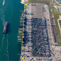
Fugro's New USV to Chart Waters Off South Australia
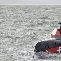
Fugro will use its new uncrewed surface vessel (USV) to chart the waters of South Australia’s Gulf St Vincent and Investigator Strait as part of the Australian Government’s HydroScheme Industry Partnership Program (HIPP).The Dutch-based offshore survey services company will carry out the 998 km2 survey will be conducted on behalf of the Australian Hydrographic Office (AHO), which will use the data to update nautical charts for safer navigation. Data will also be shared with scientific agencies…
SMA Selects Teledyne CARIS

Teledyne CARIS has announced that the Swedish Maritime Administration (SMA) has selected Teledyne CARIS to provide tools for generalization of bathymetric data in nautical charts.Through a competitive tender process, SMA has chosen Teledyne CARIS to provide CARIS BASE Editor as the solution for the generalization of bathymetric data in nautical charts. The software platform will provide the tools needed to generate contours and sounding selections using automated processes as…
NOAA to Order New Research Ships in 2020
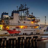
The U.S.' National Oceanic and Atmospheric Administration (NOAA) said it expects to award contracts for the construction of two new oceanographic ships by the end of the year. Once in service, the new large oceangoing, multi-mission research vessels will support missions ranging from general oceanographic research and exploration to marine life, climate and ocean ecosystem studies, NOAA said.“When completed, these new state-of-the-art ships will be vital for collecting high-quality data and leading scientific discoveries,” said Neil Jacobs, Ph.D., acting NOAA administrator.
ChartCo Names Malaika D’souza for Americas
ChartCo, the provider of navigation and compliance solutions shipping, named Malaika D’souza as its new representative for the North and South American regions.According to the distributor of navigational data, nautical charts, marine technical publications and digital products, Ms D’souza, who has successfully grown ChartCo’s revenues and customer relationships across India and the Middle East over the past 3 years has now relocated to Toronto to take up the full-time position as the commercial lead for the North and South American markets.ChartCo has taken this move to coincide with the market wide roll out of its OneOcean platform which encompasses the entire suite of ChartCo’s navigation…


