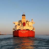
New Marine Navigation System at Port Freeport
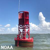
Port Freeport, located outside of Houston, is now fitted with a NOAA system that improves safe and efficient marine navigation. The technology is part of a nationwide network called Physical Oceanographic Real-Time System, or PORTS.Freeport PORTS is the 38th system in this network of precision marine navigation sensors. The integrated series of sensors track oceanographic and meteorological conditions as they unfold around the port. This will increase the navigation safety of vessels entering and exiting Port Freeport…
From Protecting National Sovereignty to Protecting the Reef
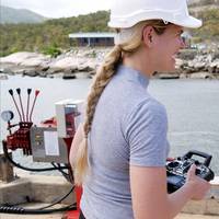
Melanie Olsen is harnessing 10 years of missile defense and electronic warfare systems expertise to drive rapid technological innovation in marine research and monitoring. Today, on International Women in Engineering Day, the AIMS Team Leader for Technology Development Engineering shares her unique journey.Growing up in a third-generation farming family near the small settlement of El Arish in north Queensland, Melanie Olsen thought engineers were train drivers.When a James Cook University engineering lecturer visited her small rural high school with a quad helicopter…
Canada Steamship Lines Decommissions 41-Year-old Bulker
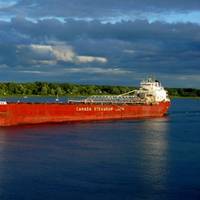
Canada Steamship Lines' 41-year-old self-unloading bulk carrier Salarium has reached the end of its service life and will be dismantled at a ship recycling yard in Turkey, CSL Group announced.The long-serving 35,656 DWT bulker made its final voyage at the end of 2019, loading salt in Bécancour, Que. on December 19 for discharge it in Oshawa, Ont. on December 27. The vessel was then laid up in Toronto until April 2020 when it was moved to Montreal.A CSL Group spokesperson told MarineLink the company will finalize the ship recycling yard in Turkey next week…
Algoma Joins Whale Conservation Efforts
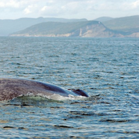
Algoma Central Corporation, the largest fleet of dry and liquid bulk carriers on the Great Lakes–St. Lawrence Waterway, is adding the crews from 27 of its vessels to an expanding network of whale watchers. For the first time, the crews on Algoma’s self-unloaders, bulkers, tankers and cement carriers will collect data about the whales they see on their journeys this summer."Algoma is committed to providing sustainable and environmentally responsible marine transportation,” said Gregg Ruhl, Algoma’s Chief Operating Officer.
High Correlation of Biomass to Species Diversity in Northern Chukchi Sea - BOEM Study
Last summer, researchers began a five year study to monitor biodiversity in the Arctic Chukchi Sea from an ecosystem perspective, looking at microbes, whales and everything in between. health and critical ecosystem services that contribute to human life. Monitoring it improves our ability to interpret and forecast changes. The unprecedented effects of climate change combined with strong seasonal cycles and increasing human activities in the Arctic make this region particularly important to monitor. In August 2015, the AMBON team of researchers from the University of Alaska’s School of Fisheries and Ocean Sciences, the University of Maryland…
NOAA, NASA & BOEM to Monitor Biodiversity
NOAA, NASA and the Department of the Interior's Bureau of Ocean Energy Management (BOEM) have joined together to support three demonstration projects that will lay the foundation for the first national network to monitor marine biodiversity at scales ranging from microbes to whales. The projects, to be funded at approximately $17 million over the next five years, subject to the availability of funds, will demonstrate how a national operational marine biodiversity observation network could be developed. Such a network would serve as a marine resource management tool to conserve existing biodiversity and enhance U.S. biosecurity against threats such as invasive species and infectious agents.
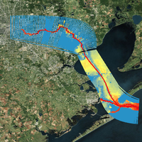
Water Monitoring to Continue at Western Gulf Ports
A water monitoring network that helps keep port traffic moving is the responsibility of the Conrad Blucher Institute (CBI) for Surveying and Science at Texas A&M University-Corpus Christi. CBI, in partnership with Woods Hole Oceanographic Institution in Massachusetts, has received the federal contract from the National Oceanic and Atmospheric Administration to continue to operate and maintain the water level and ocean monitoring network along the Western Gulf of Mexico. CBI, as a subcontractor, will operate in the Houston/Galveston and Lake Charles, La.
Woods Hole Group Clinches Multi-Year O&M Contract
Woods Hole Group will be working with the National Oceanic and Atmospheric Administration, Center for Operational Oceanographic Products and Services for the operation and maintenance of Physical Oceanographic Real Time System along the East Coast of the USA, and along the Gulf of Mexico coast in Texas and Louisiana. NOAA PORTS® is a network of sensors in ports and harbors providing access to information improving maritime commerce and safety. * Houston-Galveston, TX (http://tidesandcurrents.noaa.gov/ports/index.html?port=hg) Woods Hole Group also was awarded the five year Operation and Maintenance Contract to support four NOAA National Water Level Observation Network (NWLON) stations in Texas.
Drifter Buoys Launched from Warship
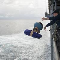
The buoys measure ocean currents up to 15 meters in depth, and were launched during 'Pacific Partnership 2013' to measure sea surface temperatures and atmospheric pressure. All are important elements in creating an observation network, allowing for more accurate weather forecasts. "The mission of Pacific Partnership is disaster relief preparedness," said Lt.j.g. Jeffrey S. Grabon, Pacific Partnership Mobile Environment Team division officer. The buoys were deployed at specific coordinates while USS Pearl Harbor transited the Pacific Ocean to Samoa…
Mobile App Boosts Navigation Safety
Conrad Blucher Institute Develops Mobile App to Increase Navigational Safety along Nation’s Second-Largest Port. Researchers have designed and are implementing a new mobile application to provide ship captains and pilots with real-time predictions of ocean water levels and currents along the Houston Ship Channel, which services the second-largest port in the United States, the ports of Houston and Galveston. The app will provide invaluable information, which could increase navigational…
Sea Level Anomaly Along U.S. Atlantic Coast
Persistent winds and a weakened current in the Mid-Atlantic contributed to higher than normal sea levels along the Eastern Seaboard in June and July, according to a new NOAA technical report. After observing water levels six inches to two feet higher than originally predicted, NOAA scientists began analyzing data from select tide stations and buoys from Maine to Florida and found that a weakening of the Florida Current Transport—an oceanic current that feeds into the Gulf Stream—in addition to steady and persistent Northeast winds, contributed to this anomaly. “The ocean is dynamic and it’s not uncommon to have anomalies,” said Mike Szabados, director of NOAA’s Center for Operational Oceanographic Products and Services.