UUV Integration Will Transform Submarine Tactics
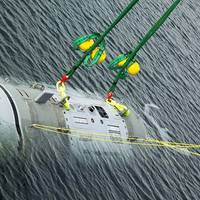
For decades, submarines have been the apex predator, roaming the oceans largely unmolested, gathering intelligence, providing a sea-based nuclear deterrent, and conducting clandestine missions with impunity. As such, these versatile and lethal platforms have been highly sought after by navies around the world, and with advancements in underwater propulsion and quieting technologies, it is perhaps more challenging than ever to detect, localize, and track them. But even as submarines become stealthier…
Lowrance TotalScan Debuts Single Transducer Solution
Lowrance announced today the evolution of convenience and superior performance in fishfinding technologies – the new Lowrance TotalScan all-in-one transducer – combining proven CHIRP sonar capabilities with exclusive high-resolution StructureScan HD and DownScan Imaging technology. With all three sonar technologies in one transducer, anglers receive the benefits of greater fish-target separation and less interference for a more clutter-free display with CHIRP Sonar, plus photo-like images of fish-holding structure on both sides of your boat with StructureScan HD – along with the same photo-like images directly beneath your boat with DownScan Imaging.
Navico to License Sonar Tech to Raymarine

Navico Holding AS, parent company to the Lowrance, Simrad and B&G brands, announced today that it has resolved the dispute with Raymarine Inc. through a license to Navico's patented DownScan sonar technologies. Raymarine and Navico have mutually agreed to dismiss all patent litigations and disputes between them. The terms of the patent license and resolution are confidential. navico.com
Raytheon Get US$35-Million Navy LCS Sonar Contract
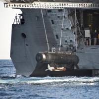
Raytheon Company says it is to provide the U.S. Navy with AN/AQS-20A minehunting sonar systems and equipment. The system leverages advanced sonar technologies to support the Navy's critical minehunting missions, ensuring safe access and passage for military and civilian vessels on the world's oceans and waterways. Deployed from the Littoral Combat Ship (LCS) as the variable depth sonar for the AN/WLD-1 Remote Minehunting System (RMS), the AN/AQS-20A system is towed undersea to scan the water in front, below and to the sides of the vehicle for anti-shipping mines.
NOAA's 'Ferdinand R. Hassler' Begins Survey Project
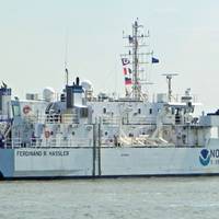
NOAA’s newest survey ship, the 'Ferdinand R. Hassler will operate mainly along the Atlantic and Gulf coasts, Caribbean Sea and Great Lakes, acquiring data to update NOAA’s nautical charts. Her mission, however, is not limited to collecting bathymetry, explains retired NOAA Capt. Andy Armstrong, co-director of the Joint Hydrographic Center/Center for Coastal and Ocean Mapping at the University of New Hampshire. Local government officials have provided a warm welcome to Hassler’s crew. Noting “the enthusiastic welcome from the townspeople and local businesses,” Hassler commanding officer Lt.
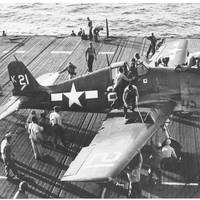
F6F Hellcat WWII-Era Aircraft Discovered off Coast of Florida
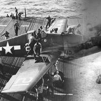
OceanGate Inc. discovers Grumman F6F Hellcat off the coast of Miami using manned submersible, 2D and 3D sonar technologies. OceanGate discovered a World War II-era Grumman F6F Hellcat plane off the coast of Miami Beach. The plane was found during one of an ongoing series of dives in which OceanGate has been using its Teledyne BlueView high-frequency sonar and high-definition photo and video equipment to gather data pertaining to the artificial reefs in Miami-Dade County waters.
WWII Era F6F Hellcat Discovered off Coast of Florida
OceanGate Inc. OceanGate announced it has discovered a World War II-era Grumman F6F Hellcat plane off the coast of Miami Beach. The plane was found during one of an ongoing series of dives in which OceanGate has been using its Teledyne BlueView high-frequency sonar and high-definition photo and video equipment to gather data pertaining to the artificial reefs in Miami-Dade County waters. Recognizing the potential historical and military significance of the find, OceanGate contacted officials at both the Smithsonian Institution and the U.S.
NOAA Commissions Survey Ship
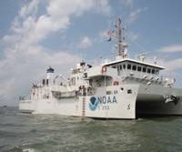
NOAA commissions high-tech coastal mapping 'Ferdinand R. Hassler' in Norfolk, Va. The new ship’s primary mission will be to detect and monitor changes to the sea floor. Data collected by the ship will be used to update nautical charts, detect potential hazards to navigation, and enhance our understanding of the ever-changing marine environment. “With the growth in the size of commercial vessels and the importance of waterborne commerce to our economic security, there is a critical need for accurate information about our coastal waterways…
NOAA Fairweather Departs on Survey Mission
NOAA Ship Fairweather, a 231-foot survey vessel, departed Kodiak, Alaska, today on a mission to conduct hydrographic surveys in remote areas of the Arctic where depths have not been measured since before the U.S. bought Alaska in 1867. NOAA will use the data to update nautical charts to help mariners safely navigate this important but sparsely charted region, which is now seeing increased vessel traffic because of the significant loss of Arctic sea ice. Over the next two months, Fairweather will conduct hydrographic surveys covering 402 square nautical miles of navigationally significant waters in Kotzebue Sound, a regional distribution hub in northwestern Alaska in the Arctic Circle.
VT Halter Marine to Build Swath Vessel for NOAA
Photo Credit: NOAANOAA announced that VT Halter Marine Inc. of Pascagoula, Miss., will complete the final design and build of a new Small Waterplane Area Twin Hull Coastal Mapping Vessel, or SWATH CMV, for the agency. NOAA exercised a $15m option for the ship with VT Halter Marine, which also completed the vessel's preliminary design under a separate option. The primary mission of the SWATH CMV will be to map the full seafloor in coastal areas for the nation's nautical charts. It will operate in waterways along the Atlantic and Gulf coasts, Caribbean Sea and Great Lakes, conducting basic hydrographic surveys of the seafloor using side scan and multibeam sonar technologies.