Navigation and Wind Farms: Competing Ocean Uses Raise Existential Questions
“Wind Turbines: The Bigger, the Better” -USDOE Office of Energy Efficiency & Renewable Energy, August 24, 2023
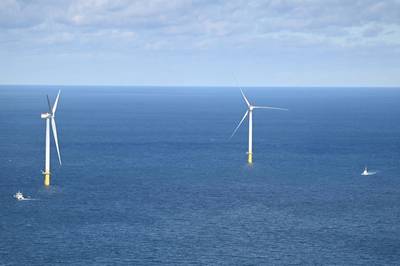
Last December the Bureau of Ocean Energy Management (BOEM) published a proposed sale notice regarding new development areas for utility scale wind projects in the central Atlantic Ocean. The notice includes an upfront issue: the need to mitigate conflicts with U.S. Department of Defense (DOD) activities. BOEM explains that in certain areas the Air Force has set an airspace floor of 1,000 feet above sea level and the Air Force asked BOEM to keep structures below that height. BOEM advises that prospective wind energy companies will need an agreement with DOD to “deconflict potential impacts”. (Today, the blades of a GE Haliade-X offshore turbine reach 853 feet above sea level.)
American Clean Power (ACP), the wind industry advocacy group, in comments to BOEM, takes on this issue. ACP writes that when Atlantic projects are built “the optimal wind turbine generator (WTG) height would exceed this restriction” and that “a condition restricting height to 1,000 feet would be very problematic”, impacting a project’s financial and technical viabilities. ACP suggests that BOEM and the Air Force work something out.
As offshore wind projects advance that old riddle from eighth-grade science comes to mind: What happens when an unstoppable force meets an immovable object? As wind energy projects speed up, issues of competing ocean uses are forced into sharper, and harder, focus. When finalized, wind energy areas (WEAs) will impact vast ocean areas and pressure is building to find answers about competitive uses: about safely navigating and operating within, around, through, above and below the interconnections of a wind tower network covering thousands of acres.
Among federal agencies, say, between BOEM and the U.S. Coast Guard, this seems to remain a cooperative, friendly effort. Nevertheless, in recent agency filings in response to BOEM’s proposed Atlantic WEAs, certain standout issues, and positions, are emerging, issues from navigational safety to fisheries to whales and mammals to undersea cables to weather monitoring and warning systems, even to cultural issues such as historic preservation. Agencies write: we want to advance wind energy, but ocean areas can only yield so much before a benign balance is tipped. Balance is the hard part and officials have to get it right because new ocean-based infrastructure and operations pose consequences for maybe the next 100 years.
 (Photo: Emily Velez / U.S. Coast Guard)
Safe transit: Coast Guard has “several equities”
BOEM’s December sale Notice also advises energy companies that vessel navigation and safety may present operational restrictions, that “portions of the lease areas may not be available because of navigational safety concerns” and that BOEM may require additional mitigation measures depending on future navigational safety risk assessments. Overall, however, navigation is just a brief reference within BOEM’s Notice: one paragraph in 12 pages.*
The Coast Guard is charged with safeguarding the viability of the Marine Transportation System (MTS), and the USCG is closely tracking issues of competing ocean uses. The USCG is one of the federal agencies that responded to BOEM’s Atlantic sale notice.
In a letter to BOEM signed by Steve Ramassini, Chief of the USCG’s Office of Navigation Systems, Ramassini writes that the Coast Guard has “several equities” tied to offshore energy. Ramassini writes directly that the CG “opposes priorities that place undue strain on the MTS or impede the execution of our statutory missions,” which include, of course, search and rescue. Ramassini writes that it is “critical for BOEM to resolve conflicts prior” to auctioning energy lease areas.
For navigation safety, Ramassini suggests that BOEM focus on and include the following priorities:
- Avoid shared leases in order to set spacing and straight-line vessel routes.
- If deliberate separation isn’t feasible additional marking and lighting should include Automatic Identification System Aids to Navigation to alert mariners of changes in spacing and/or orientation.
- Regardless of layout and location, the CG “insists” that mooring systems and ancillary equipment are contained inside the approved lease area as a requirement under the terms and conditions of a specific lease.
- For structure siting, the USCG (again) “insists” that BOEM apply the Marine Planning Guidelines detailed in Enclosure 4 to Navigation and Vessel Inspection Circular 02-23 (“Guidance on the Coast Guard’s Roles and Responsibilities for Offshore Renewable Energy Installations (OREI) on the Outer Continental Shelf (OCS).” This 69-page document details degrees and types of risk for different vessels and vessel combinations. Towing at sea, for example, presents significantly different issues, e.g, maneuvering, compared to a single vessel. A tow-wire catenary can require significantly greater water depths than the drafts of the tug or barge. Therefore, submerged cabling and infrastructure need to be at depths that allow all such operations.
Importantly, Ramassini advises BOEM of the USCG’s recent work on ocean transit and wind towers. He directs BOEM’s attention to the USCG’s recent 27-page Federal Register Notice (January 19) to establish “shipping safety fairways along the Atlantic coast.” He notes that two possible fairways are adjacent to lease areas off the Delaware Bay and the Virginia coast.
In its Notice, the Coast Guard asserts that ocean fairways – as well as “traffic separation schemes” and “precautionary areas” – would confirm a central mission: maintaining and securing safe navigable waters for vessels transiting waters subject to U.S. jurisdiction.
| TERMS – U.S. Coast Guard |
| •A shipping safety fairway is a lane or corridor free of fixed structures. It sets aside areas of sufficient depth and dimensions to accommodate vessels and to allow for the orderly and safe movements of vessels transiting to or from ports. |
| •A TSS – traffic separation scheme – is a designated routing measure that separates opposing streams of traffic into traffic lanes, in which vessels all travel in roughly the same direction. |
| •A precautionary area is a designated routing measure with defined limits, where vessels must navigate with caution. |
The USCG proposes 18 fairways and one fairway anchorage (see map).
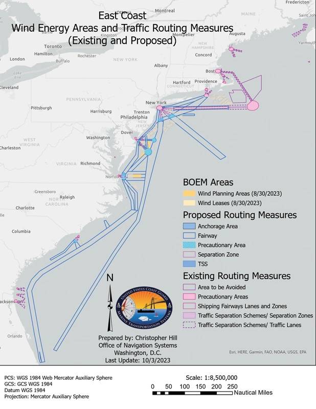
Formally established fairways would codify – and protect – historically traveled shipping routes. Fairways would facilitate offshore development, the Coast Guard writes, by preserving traditional routes and maintaining navigational safety “amidst growing offshore activity along the Atlantic Coast.” Fairway designations would “ensure that these navigation lanes remain free of fixed structures.” Depending on location, the lanes would be between 4 and 35 miles wide.
For the USCG, BOEM’s assessments cover small, static ocean areas, too small for the USCG’s environmental review and rulemaking. The Coast Guard process requires “an analysis with a broader scope along the entire Atlantic Coast.”
Importantly, the USCG writes that fairway use is not mandatory. Vessels could continue to traverse U.S. jurisdictional waters without restriction. But with fairways captains would know they could depend on established routes, permanently clear of fixed structures. Without the rule new projects might be set within historical vessel routes, conflicting with existing maritime uses and users.
The USCG’s fairway proposal is based on BOEM’s existing WEA projections (contained in the December Notice). The 18 proposed fairways, traffic separation schemes and precautionary areas, the USCG asserts, “do not intersect, limit, remove, or in any other way interfere” with further development of the Atlantic lease areas. It’s important to keep in mind, of course, that federal officials seek 30 gigawatts (GW) of offshore wind by 2030. Then, by 2050, 110 GW, almost a four-fold increase. In its January Notice, the USCG asks for comments about “how future offshore energy development may be impacted by this proposed regulation, and whether any alternative fairway orientations could reduce those impacts while preserving navigational safety.”
Commercial vessel navigation is just one competing ocean issue, of course. Commercial fishing boats can have similar concerns, but also very different concerns, since fishing vessels, to reach fish and gear, may need to move in and out of designated fairways. For helicopter crews, wind towers make search and rescue more difficult, both because the towers stand as obstacles and because of turbulence.
Plus, there are somewhat indirect maritime concerns. Google, for example, notes its support for wind power, but has questions about submerged communication and data cables. Google suggests that BOEM, when selecting and developing WEAs, should consider cable installation and maintenance, not just current cable placements, but also future installation.
Google notes that one proposed Atlantic WEA intersects an existing cable system (the “Dunant system”). “Future development of surface and seabed infrastructure,” Google advises BOEM, “has the potential to severely restrict Google’s ability to maintain Dunant if the cable's presence is not identified and considered during early stage planning activity.”
BOEM’s December lease document does not mention undersea cables and related systems, neither existing nor future systems. Offshore wind requires extensive cabling. For example, in March, the Army Corps approved a permit (River and Harbors Act of 1899) for Orsted’s Revolution Wind project approximately 15 miles south of Rhode Island. The ACE permit area could include up to 65 wind turbines, eventually requiring 155 miles of inter-connecting cables, 9 miles of cables connecting substations and up to two export transmission cables with “associated secondary cable protection” (text is from the permit) within a 42-mile-long offshore export cable corridor extending from the lease area north into Rhode Island Sound and Narragansett Bay, making landfall near Quonset Point in North Kingstown, R.I. Orsted must submit a scour and cable protection plan at least 120 days before starting scour and cable protection efforts. A monitoring plan is also required.
 (Photo: South Fork Wind)
Wind towers and radar degradation
Concerns about wind towers and radar degradation remain an open set of issues. These concerns extend beyond vessels and aircraft to weather and environmental monitoring, search and rescue and tracking environmental accidents, such as oil spills. Problems with radars and wind towers have been known for at least a decade but the topic received high level attention in February 2022, when the National Academy of Sciences published a report “Committee on Wind Turbine Generator Impacts to Marine Vessel Radar.” (BOEM was a Report sponsor.) Turbine blades and towers skew radar performance, resulting in blurred, undependable information for vessel crews.
In the fairways Notice, the USCG references the NAS study, that vessels navigating in wind farms “could experience interference and reflectivity due to the turbine structures and blades which could lead to degrading effectiveness and confusing navigational pictures. The unique combination of factors in wind farms may lead to reduced navigational effectiveness and lost contact with smaller objects such as buoys, smaller commercial fishing vessels, and recreational vessels.”
The USCG’s references to radar issues are oblique. (The USCG’s Federal Register text does not even include the word “radar”; the word only appears in a footnote referencing the title of the NAS report.) The Coast Guard does not ask for insights or comments on how or whether radar failure might be important – or not – within fairways. The Coast Guard recommends “additional caution” through WEAs. But within the proposed fairways, the USCG text implies that commercial vessels won’t need radar, that vessels will be able to proceed “without experiencing significant degradation in navigation.” It’s not clear whether that safety – without radar – also extends to traffic separation operations and cautionary zones.
In comments to BOEM, NOAA raises radar issues, although indirectly and not linked to navigation concerns, say, for NOAA’s own fleet. Rather, NOAA hands-off the issue to its Integrated Ocean Observing System which suggests that BOEM include a requirement, as a condition of project approval, that wind companies “must develop a high frequency radar wind tower interference mitigation plan.” IOOS notes that none of the mitigation measures mentioned among BOEM’s discussion documents are helpful for IOOS radar.
After the NAS 2022 report, the volunteer expert study committee disbanded. Since then, according to the study’s chair, no one from any federal agency has contacted committee members seeking advice about following up on the study’s recommendations. The NAS study – BOEM’s study – sits on the proverbial shelf.
DOE seems to be leading next steps on radar/wind turbine research. Two recent efforts of note include –
- A request for information, published last November 2023, seeking insights about correcting wind tower/radar degradation. Comments were due in January. But DOE will not share the comments it received (if any). A DOE spokesperson said, “We are not currently in a position to share the responses received for this RFI.” A freedom-of-information request was unanswered by the deadline for this report.
- Just over a year ago, in January 2023, DOE along with Defense, FAA, NOAA and BOEM signed an updated (from 2016) Memorandum of Agreement for the “Establishment of the Wind Turbine Radar Interference Mitigation Working Group.” (Note: The Coast Guard and Homeland Security are not part of the MOA.) The MOA was to establish an Executive Steering Group, approve a 5-year study plan and prepare a yearly progress report, among other significant tasks.
DOE was asked about the yearly progress report. A spokesperson said a 2023 report was completed but the report falls into the Controlled Unclassified Information (CUI) category and cannot be released to the public. A “multi-agency review” will occur in March. Then, a steering group will discuss whether portions of the report may be released. No answer about why this material is classified.
The USCG is accepting public comments on the proposed fairways until April 18.
With offshore wind and competing ocean issues, many topics still need to be resolved.


