NOAA Updates New York Harbor Charts Post-Sandy
Ships, barges, ferries, and recreational boats in the busy New York Harbor will be able to navigate more safely thanks to an updated version of the harbor’s nautical chart recently issued by NOAA that includes data gathered in the navigational response to the damage caused by Sandy in October 2012.
The latest edition of Chart 12334 – New York Harbor includes new depth measurements and shoreline depictions.
“This new chart edition is the first product of a multi-year post-Sandy charting plan,” said Rear Admiral Gerd Glang, director of NOAA’s Office of Coast Survey. “We have NOAA vessels and private contractors surveying coastal areas affected by Sandy through this year and next, acquiring the data we will use to update nearly two dozen East Coast nautical charts.
“It normally takes more than a year, and sometimes four years or more in very complicated areas, to create a new chart edition,” Glang said. “In this case, we were able to use data we gathered to help the repair efforts at the Statue of Liberty, merge it with depth measurements collected by the U.S. Army Corps of Engineers, and push it ahead as a priority since the Port Authority of New York and New Jersey is so essential to the nation’s economy.”
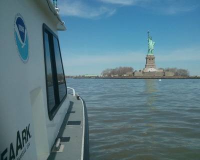
The new chart edition is the result of combined efforts of several federal agencies. Following up on its survey response immediately after the storm, NOAA began acquiring more post-Sandy hydrographic data in April. A Coast Survey navigation response team, equipped with high-tech surveying equipment, searched for underwater storm debris and mapped the depths surrounding Liberty Island and Ellis Island.
The surveys helped the National Park Service, which was working to reopen the Statue of Liberty in time for Independence Day. The NOAA team also surveyed nearby shipping channels and the Port Authority’s Global Terminal to provide more up-to-date navigational information for maritime commerce. In all, the team surveyed more than 110 linear nautical miles, through 119 hours, collecting over 578 million depth measurements. Data acquired by surveyors with the U.S. Army Corps of Engineers also contributed significantly to the new edition.
The new chart edition also has updated shoreline depictions, acquired by aerial photography from NOAA National Geodetic Survey’s Remote Sensing Division.
Chart 12334 – New York Harbor is now available as a paper Print-on-Demand nautical chart, as a free PDF digital download, and as a free raster navigational chart for electronic display systems. The federal government will print the chart in traditional lithographic style for chart agents to sell starting later this month. The corresponding electronic navigational chart US5NY1C will be available for download in late January.
noaa.gov


