SOI: Amidst Pandemic, Seafloor Mapping Zooms Ahead


Scientists working remotely with Schmidt Ocean Institute (SOI) have completed a first look at deep waters in the Coral Sea, despite the continuing COVID-19 pandemic. As one of the only at-sea science expeditions to continue operations, the team has discovered the deepest living hard corals in Eastern Australian waters, sighted fish in new regions and identified up to 10 new marine species.
SOI’s R/V Falkor spent the 46 days in the Coral Sea Marine Park, one of the largest protected areas in the world. Scientists connected remotely to the ship from their homes, collecting high-resolution seafloor maps and video footage of the ocean down to 1,600 meters. Led by chief scientist Dr. Robin Beaman of James Cook University, the expedition enabled the team to develop a better understanding of the physical and long-term changes of deep-sea reefs.
The effort mapped more than 35,500 square kilometers of the seafloor, revealing 30 large coral atolls and banks, submarine canyons, dune fields, submerged reefs and landslides. Previously, only the shallower parts of these reefs had been mapped, and until now, no detailed mapping data existed of the deeper areas. The maps created will be available through AusSeabed, a national Australian seabed mapping program, and will also contribute to the Nippon Foundation GEBCO Seabed 2030 Project. “This expedition has provided us with a unique window into both the geological past and the present-day conditions, allowing scientists and park managers to see and tell the full story of the interconnected environments,” said Dr. Beaman. “This vision is invaluable for science, management and education.”
More than 91 hours of high-resolution video surveys were collected with Falkor’s underwater robot, SuBastian, showing no evidence of coral bleaching below 80 meters. “We know that the shallower coral counterparts are currently undergoing their third mass bleaching event in five years, so it’s an invaluable insight for scientists and managers to know how deep that bleaching extends,” said Dr. Jyotika Virmani, SOI’s new and first executive director. The data collected on SuBastian’s 14 historic dives has been shared through more than 74 hours of video surveys, all available on SOI’s YouTube channel and website. The live-streamed dives created an online platform, drawing spectators from around the world to witness the unique species that were observed. “The footage coming from our dives is just astounding,” Virmani said. “The Falkor’s robust telepresence technology has allowed scientists from all over the world to collaborate on some of these discoveries. The data will greatly advance the characterization of Australia’s massive and ecologically important marine estate.”
Falkor will return to the Coral Sea Marine Park for an additional month of research at the end of July.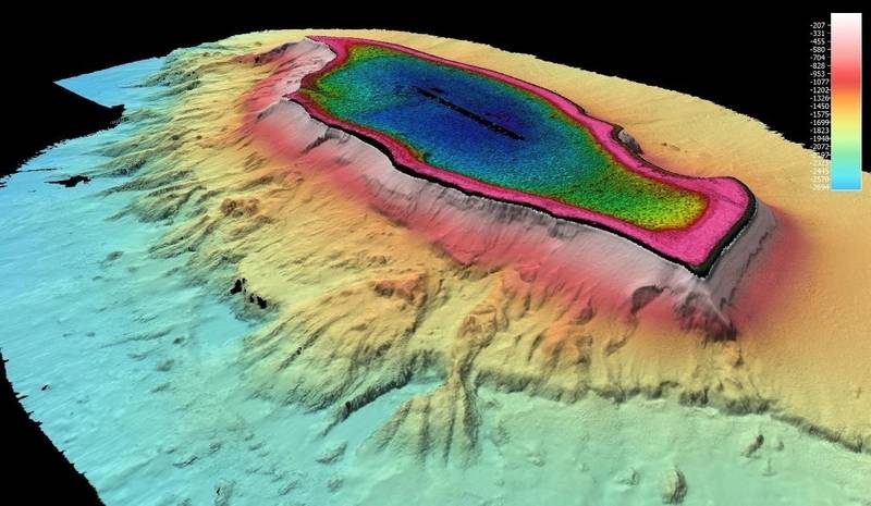 Osprey Reef is an atoll lying on the northwestern side of the Queensland Plateau within the Coral Sea Marine Park, Australia. Osprey Reef is roughly oval, measuring 25 by 12 kilometers, and covers around 195 square kilometers. The newly released Falkor data mapped around the steeper flanks. © Schmidt Ocean Institute