UN Agencies Call for Protection of Satellite Navigation

Increasing incidents of interference with aviation, maritime and other satellite telecommunications services mean States need to urgently enhance their protection of a critical radio-frequency band, the International Telecommunication Union (ITU), the International Civil Aviation Organization (ICAO), and IMO said in a joint statement.These cases of harmful interference are in the form of jamming and spoofing that disrupt Global Navigation Satellite Systems (GNSS) operating in the frequency bands allocated to the Radio Navigation Satellite Service (RNSS).
USCG Navigation Center: Steering a steady course for safe, secure, efficient waterways

The U.S. Coast Guard’s Navigation Center (NAVCEN) is involved in a number of activities that have an impact on all Americans, even if they don’t realize it.From motorists checking directions with their Global Positioning System (GPS) to boaters to ships coming and going to U.S. ports, the NAVCEN plays an unseen but vital role.With a staff of19 officers, 17 enlisted personnel and 19 civilians, NAVCEN falls under the Director of Marine Transportation Systems (CG-5PW) at USCG Headquarters…
Britain Reviewing Risks to its Satellite-Reliant Infrastructure

Britain is reviewing its reliance on satellite-based technology for critical infrastructure including the Global Positioning System (GPS) as the threat of jamming attacks and disruptions grows, a government report said on Tuesday. Emergency services, transport, communications and financial networks are among key sectors which depend on Global Navigation Satellite Systems (GNSS) such as GPS. Such technology needs accurate and reliable position and timing signals. Experts say the problem with GNSS is their weak signals…
Cyber Threats Prompt Return of Radio for Ship Navigation

The risk of cyber attacks targeting ships' satellite navigation is pushing nations to delve back through history and develop back-up systems with roots in World War Two radio technology. Ships use GPS (Global Positioning System) and other similar devices that rely on sending and receiving satellite signals, which many experts say are vulnerable to jamming by hackers. About 90 percent of world trade is transported by sea and the stakes are high in increasingly crowded shipping lanes.
EU Pulls Plug on Back-Up Nav System
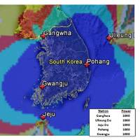
A British-led initiative to create a back-up to satellite navigation systems for ships has been pulled after failing to garner interest from other European countries, despite its proponents pointing to the growing risk of disasters at sea. Vessels increasingly rely on devices that employ satellite signals to find a location or keep exact time, including the Global Positioning System (GPS). Paper charts are used less frequently due to a loss of traditional skills among seafarers. Experts say GPS is vulnerable to signal loss from solar weather effects or radio and satellite interference or deliberate jamming, which South Korea experienced from North Korea in recent years.
Threats to Global Navigation Satellite Systems
Originally developed to guide Allied convoys safely across the Atlantic, the use of synchronized low frequency radio signals as a navigational aid revolutionized modern maritime navigation in the 1940s. Faced with operating ships and aircraft over vast areas, researchers pioneered the use of radio signals to aid navigation in regions where poor weather conditions made traditional methods—such as dead reckoning and celestial navigation—exceptionally difficult. This system was eventually named LORAN.
Rising from the Ashes

The federal government is now taking steps to reverse its 2010 decision to terminate the nation’s LORAN program. The LORAN program was initiated during World War II, when US and Allied forces fighting in the Pacific Theater needed a good means of navigation in that vast ocean. The US Coast Guard was charged with establishing and operating chains of Loran-A stations throughout the Pacific. With war’s end, the program was extended to coastal areas of the United States and elsewhere. Over time, Loran-A was replaced by Loran-C, which provided both greater coverage and improved accuracy.
Fugro Introduces G2+ Positioning Service
Fugro has introduced its high accuracy G2+ service for the GNSS augmentation field, the company announced today. The G2+ service is designed to benefit offshore operators around the globe who require positioning and measurement accuracy at the centimeter level. G2+ is an enhancement of Fugro’s G2 service (based on GPS and GLONASS) and utilizes highly advanced GNSS augmentation algorithms developed in-house. The code and carrier-phase signals transmitted by GPS and GLONASS satellites are monitored globally by Fugro’s worldwide network of reference stations. These observations are processed centrally in real-time using the company’s proprietary algorithms to generate precise corrections which are used to augment the standard signals broadcast by GPS and GLONASS satellites.
Fugro Launches G4 Service
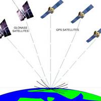
Fugro has further extended its technology leadership in the field of GNSS augmentation systems for offshore positioning applications with the launch of its G4 service. The new satellite correction service is the first to take advantage of all four GNSS (Global Navigation Satellite Systems): GPS, GLONASS, BeiDou and Galileo. GNSS augmentation services significantly improve position accuracy compared to unaided GNSS receivers, which are commonly used in the consumer sector. By using all available GNSS satellites, Fugro’s G4 service is designed to improve availability and reliability of offshore positioning and will thus enhance the safety and productivity of a wide range of survey and other activities offshore.
General Dynamics gets $25 mi GPS Contract from Lockheed Martin
General Dynamics Advanced Information Systems, a business unit of General Dynamics, was awarded a $25.4 million full-production contract from Lockheed Martin to support the U.S. Air Force Global Positioning System (GPS) III Network Communications Element (NCE) for space vehicles seven and eight (SV 07-08). The Air Force's next-generation GPS III satellites will improve position, navigation and timing services and provide advanced anti-jam capabilities yielding superior system security, accuracy and reliability. "For more than 50 years, we have been a premier provider of spacecraft communications and navigation equipment for the nation's military and government agencies…
Lockheed Martin Awarded Contracts Two GPS lll Satellites

Lockheed Martin inform that the U.S. Air Force has awarded it more than $245 million in contract options to complete production of its seventh and eighth next-generation Global Positioning System satellites, known as GPS III. “With eight GPS III satellites now fully under contract, the GPS III program is moving from development into recurring production,” said Mark Stewart, vice president of Lockheed Martin’s Navigation Systems mission area. GPS III is an important program for the Air Force…
GPS lll Progress Report Update From Excelis

Exelis says it has successfully completed and fully tested six transmitter assemblies, which are integral payload components for the first in a series of the next generation of GPS III navigation satellites. The navigation payload transmitters carry high-powered GPS signals from space to Earth, benefitting military, commercial and civilian users. To ensure the space vehicle navigation payload meets performance requirements over the mission life, Exelis subjected the transmitter assemblies to a rigorous test program which includes random vibration…
Fugro Awarded Five-Year Positioning Contract by DOF ASA
Fugro has won a contract from DOF ASA for the provision of precise satellite positioning for the entire DOF fleet of more than 70 vessels globally. The contract is valid for a firm five years with two optional years and also includes the new vessels in DOF’s continuously expanding fleet. DOF an owner and operator of purpose-built vessels providing services to the offshore energy sector across the entire offshore lifecycle. Fugro, a provider of precise satellite positioning to the offshore oil and gas industry, will provide three completely independent high precision differential Global Navigation Satellite Systems to DOF. In addition DOF’s subsea vessels will be equipped with state-of-the-art hardware and software developed by Fugro, providing a truly independent solution for each vessel.
GPS lll Satellite Build Contract Goes to Lockheed Martin
The U.S. Air Force has awarded Lockheed Martin more than US$200-million in contract options to complete production of its fifth and sixth next-generation Global Positioning System satellites, known as GPS III . Lockheed Martin explain that the GPS III improves capability to meet the evolving demands of military, commercial and civilian users. GPS III satellites will deliver three times better accuracy; provide up to eight times improved anti-jamming capabilities; and include enhancements which extend spacecraft life 25 percent further than the prior GPS block.
Leica and NovAtel Will Develop Technologies For GPS
Leica Geosystems and NovAtel Inc. have entered an agreement to develop new technologies for global positioning systems (GPS). This is particularly relevant for equipment that will be based on the new upcoming Global Navigation Satellite Systems (GNSS). In the mid-eighties Leica Geosystems was one of the first companies to develop and market GPS surveying systems. NovAtel, founded in 1978, also has the reputation of being one of the most successful innovators of advanced concepts in GPS technologies. These include significant contributions to the development of Satellite Based Augmentation Systems (SBAS) such as WAAS, MSAS and EGNOS.
GNSS Guidelines Update
After an extensive review and update, the former UKOOA document “Guidelines for the use of GPS in offshore surveying” has been jointly issued as a new document by theInternational Association of Oil & Gas Producers (OGP) and the International Marine Contractors Association (IMCA). The document was reviewed by a workgroup comprising representatives of OGP’s Geomatics Committee and IMCA’s Offshore Survey Division Management Committee, as well as representatives from the marine survey industry. The use of satellite positioning is critical to the success of a wide variety of oil and gas related surveying and positioning projects. The “Guidelines…
NOAA to Ensure GPS Accuracy
NOAA will lead an international effort to pinpoint the locations of more than 40 global positioning satellites in Earth orbit, which is vital to ensuring the accuracy of GPS data that millions worldwide rely upon every day for safe navigation and commerce. NOAA personnel will compile and analyze satellite orbit data from 10 analysis centers worldwide to ensure the accuracy of GPS information. For the next four years NOAA’s National Geodetic Survey will serve as the Analysis Center Coordinator for the International Global Navigation Satellite Systems Service, a voluntary federation of more than 200 organizations that provide continuous global satellite-tracking data.
VTC Gets $6.4m Contract
The upgrade of DGPS stations includes adding capability to use Modernized GPS signals and the additional functionality required for tracking the future Galileo and GLONASS signals without further complex upgrade. The upgrade program will also ensure that the GLA service is compliant with the latest International Maritime Organization (IMO) Resolutions and recommendations from the International Association of Lighthouse Authorities (IALA). VTC will also provide ongoing support of DGPS for a further 10 years. The award of this contract builds on VTC’s expertise in the field of electronic navigation and its relationship with the GLAs, where it is delivering a state-of-the-art eLoran navigation service from its radio communications facility in , as part of a 15 year contract signed in 2007.
New Satellite Navigation Service from Fugro
Oslo based navigation specialist Fugro Seastar AS has announced the introduction of a new service: SeaSTAR G2. This new high performance navigation service combines the navigation satellites of both the American GPS constellation and the Russian GLONASS constellation, to produce a composite GPS/GLONASS position solution. The service utilizes Fugro’s own network of dual system reference stations to calculate ‘orbit and clock’ errors on a satellite by satellite basis for all 50…