MarineTraffic Partners With exactEarth
MarineTraffic is partnering with exactEarth to deliver additional real-time information to its users.The additional satellite data compliments the MarineTraffic coastal receiver network: the world's largest and most extensive system consisting of 3,500 points of presence allowing for real-time vessel tracking data of most of the global shipping fleet. The addition of exactEarth data to the existing satellite dataset on MarineTraffic will particularly enhance the visibility of vessels in both the Gulf of Mexico and the South China Sea.
PortVision: A Helping Hand in the Deepwater Horizon Response
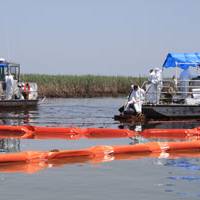
MarineNews spoke with Dean Rosenberg, CEO of PortVision, about the company’s role in the coordination of the Deepwater Horizon spill response in the Gulf of Mexico. PortVision is a web-based service that uses data from the Automated Identification System (AIS), mandated by the IMO and the U.S. Coast Guard, to provide shore-side users with real-time vessel tracking as well as historical reporting. “The main purpose for AIS, why it was mandated, is for collision avoidance,” Rosenberg said.