Transas has teamed up with Theyr Ltd (UK) to incorporate weather and ocean data within the Transas Navi-Planner 4000.
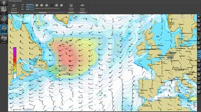
With the weather data from Theyr, the Transas Navi-Planner 4000 will provide end-users with important features like ON / OFF toggling of the weather overlay and its customization, weather update (forecast) by request with indication of required region and weather parameters, spot weather (weather under cursor), weather graphs, route optimization and voyage planning extension by weather information.
The weather and ocean data parameters include wind speed, barometric pressure, precipitation, air temperature, sea surface temperature, tropical storms and hurricanes, visibility, significant wave height, period and direction.
High and low-resolution data outputs are available. Data is fully compressed for the efficient and cost-effective delivery over any network.


