Raytheon Anschütz Debuts New ECDIS Features
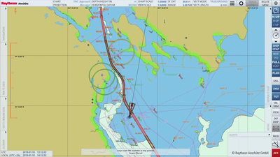
Raytheon Anschütz has released a range of new features for electronic chart display and information systems (ECDIS) to improve specialized mission capabilities such as tactical operation and collaboration.
The so-called "Plus Features" include a variety of navigational aids and overlays, which are typically required for coast guard or naval ships, offshore and research ships and megayachts.
Raytheon Anschütz , a business of Raytheon Technologies, said other key features include:
- Search and rescue (SAR) operations based on IMO (International Maritime Organization) IAMSAR Manual Volume III, which are now supported quickly and easily with multiple search patterns.
- GeoObjectEvents to enable offshore and fishery control vessels to watch a certain sea area. It can also be used for MARPOL Annex VI emission control areas (which can be imported from IMO website).
- Target intercept to calculate a course to steer to reach a target at a given speed in the shortest possible time – typically required from "blue forces" or pilots.
- OUTHOUSE, which defines a fixed common reference position for a helicopter and its landing platform – for example on offshore vessels or megayachts.
From July 2021, any feature is available as a software option for any existing ECDIS NX installation.
ECDIS NX is a fully compliant IMO ECDIS software application with a modern and intuitive user interface. ECDIS NX includes standard advanced features for route planning, voyage management and route monitoring.


