Marine Link
Saturday, December 14, 2024

Docking Errors Caused Cruise Ship Allision -NTSB

Maritime Activity Reports, Inc.

March 7, 2017

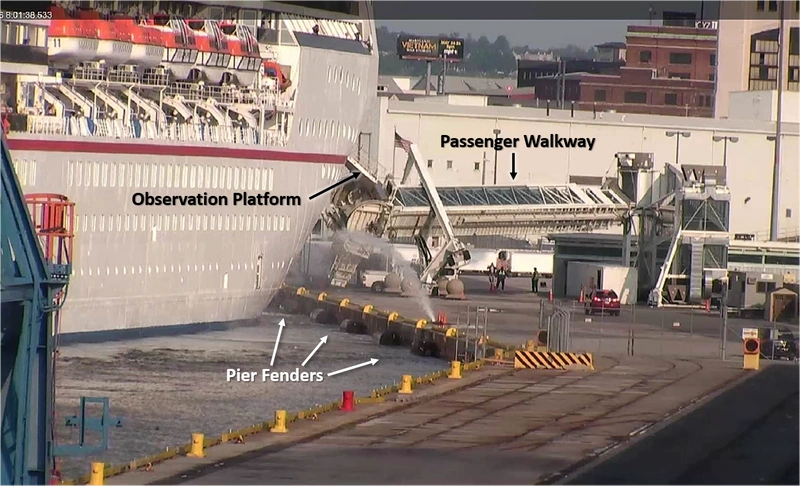
  • Screen shot from a CCTV monitor, provided to the NTSB by the U.S. Coast Guard, shows the allision of the Carnival Pride with the pier at Cruise Maryland Terminal, South Locust Point, Baltimore Harbor, Md., as the elevated passenger embarkation walkway falls and crushes three vehicles parked below on the pier (Photo: USCG / NTSB)
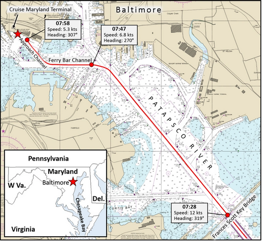
  • This excerpt of National Oceanic and Atmospheric Administration (NOAA) chart 12281 depicts the approach to the Cruise Maryland Terminal, South Locust Point, Baltimore Harbor, Md., via the Patapsco River. The red star denotes the accident location and the red line shows the track of the Carnival Pride as it proceeded to the berth on May 8, 2016. (NTSB graphic)
  • Screen shot from a CCTV monitor, provided to the NTSB by the U.S. Coast Guard, shows the allision of the Carnival Pride with the pier at Cruise Maryland Terminal, South Locust Point, Baltimore Harbor, Md., as the elevated passenger embarkation walkway falls and crushes three vehicles parked below on the pier (Photo: USCG / NTSB) Screen shot from a CCTV monitor, provided to the NTSB by the U.S. Coast Guard, shows the allision of the Carnival Pride with the pier at Cruise Maryland Terminal, South Locust Point, Baltimore Harbor, Md., as the elevated passenger embarkation walkway falls and crushes three vehicles parked below on the pier (Photo: USCG / NTSB)
  • This excerpt of National Oceanic and Atmospheric Administration (NOAA) chart 12281 depicts the approach to the Cruise Maryland Terminal, South Locust Point, Baltimore Harbor, Md., via the Patapsco River. The red star denotes the accident location and the red line shows the track of the Carnival Pride as it proceeded to the berth on May 8, 2016. (NTSB graphic) This excerpt of National Oceanic and Atmospheric Administration (NOAA) chart 12281 depicts the approach to the Cruise Maryland Terminal, South Locust Point, Baltimore Harbor, Md., via the Patapsco River. The red star denotes the accident location and the red line shows the track of the Carnival Pride as it proceeded to the berth on May 8, 2016. (NTSB graphic)

 Too much speed and too steep of an angle of approach resulted in the May 8, 2016, allision involving the cruise ship Carnival Pride in which more than $2 million in property damage occurred, according to a National Transportation Safety Board (NTSB) marine accident brief released Tuesday.

 
No fatalities, injuries or damage to the environment were reported in connection with the Carnival Pride’s allision with the pier at Cruise Maryland Terminal, South Locust Point, Baltimore Harbor, Md. Property damage resulting from the allision was estimated at more than $2 million and involved the destruction of an elevated passenger walkway, damage to three vehicles on the pier, and damage to the Carnival Pride’s hull and observation and mooring platform.
 
The Carnival Pride’s staff captain (second in command) had the conn of the vessel and allowed the vessel to approach the pier too fast and at an angle too steep. The staff captain, upon recognizing the situation, attempted to shift to manual controls but was unable to assume manual control at the bridge wing station. A Maryland pilot was aboard the vessel but had transferred conn of the cruise ship to the ship’s staff captain for the final approach and docking per the agreement between the Association of Maryland Pilots and passenger vessels berthing at the cruise ship terminal.
 

Subscribe for
Maritime Reporter E-News

Maritime Reporter E-News is the maritime industry's largest circulation and most authoritative ENews Service, delivered to your Email five times per week