

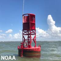
NOAA Installs Navigation System in Boston Harbor

NOAA has installed a Physical Oceanographic Real-Time System (PORTS®) in Boston Harbor. The system includes observational equipment at MassPort’s Conley Terminal and on the Tobin Memorial Bridge.The Boston Harbor PORTS, established in partnership with the Massachusetts Department of Environmental Protection, is the 41st installation in a broad, public-private partnership program, providing commercial and other vessel operators with accurate and reliable real-time information about…
NOAA Guides Easier Hudson River Navigation
Real-time data on coastal conditions will support improved maritime navigation in New York.Navigating New York waterways just got a bit easier. NOAA and the New York State Department of Environmental Conservation announced the establishment of the Hudson River Estuary Physical Oceanographic Real-time System (PORTS). The system delivers real-time oceanographic and meteorological observations that can improve maritime safety and inform coastal resource management in the region.
NOAA Unveils FLA Keys Marine Sanctuary Restoration Blueprint
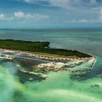
After more than a decade of collaboration with cooperating agencies, community experts and public input, NOAA today released the final management plan and environmental impact statement for Florida Keys National Marine Sanctuary.The documents outline NOAA’s regulatory recommendations and mark a critical milestone in the most comprehensive public process to restore the Florida Keys’ delicate ecosystem.The first management plan update since 2007 — crafted with extensive collaboration among NOAA…
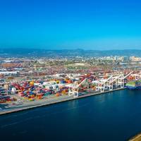
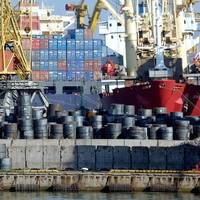
US Marine Economy Continues Growth Trend -Report
Sales and jobs in the United States' marine industry are on the rise, according to the most recent statistics from the annual Marine Economy Satellite Account (MESA) released by two Department of Commerce agencies — NOAA and the Bureau of Economic Analysis (BEA).In 2022, the American marine economy contributed a total of $476 billion in economic impact, making up nearly 2% of the nation’s gross domestic product (GDP). It generated $777 billion in sales, and supported 2.4 million jobs in 2022.“A strong, sustainable marine economy helps build a greater, more Climate-Ready Nation,” U.S.
NOAA and American Pilots’ Association Partner to Enhance Navigation Safety
On July 17, 2023, senior leaders of the American Pilots’ Association (APA) and the National Oceanic and Atmospheric Administration (NOAA), National Ocean Service, Office of Coast Survey signed a Memorandum of Agreement (MOA) that calls for the two parties to cooperate and share information so that APA and NOAA can better carry out their respective roles and responsibilities related to safe maritime navigation in America’s ports and waterways. Rear Admiral Benjamin Evans (Director…
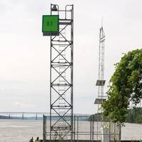
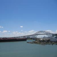
New Marine Navigation System at Port Freeport
Port Freeport, located outside of Houston, is now fitted with a NOAA system that improves safe and efficient marine navigation. The technology is part of a nationwide network called Physical Oceanographic Real-Time System, or PORTS.Freeport PORTS is the 38th system in this network of precision marine navigation sensors. The integrated series of sensors track oceanographic and meteorological conditions as they unfold around the port. This will increase the navigation safety of vessels entering and exiting Port Freeport…
Blue Economy Contributes $361 Billion to US GDP
America’s marine economy contributed about $361 billion of the nation’s gross domestic product in 2020. That is according to the most current results of the annual Marine Economy Satellite Account released today by two Department of Commerce agencies, NOAA and the Bureau of Economic Analysis (BEA).These numbers are from the first year of the coronavirus pandemic and represent a 5.8%, or $23 billion, reduction in real terms (adjusted for inflation) from 2019, outpacing the general…
Researchers Set to Explore Historic Shipwreck off North Carolina
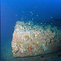
NOAA scientists and partner researchers are set to explore the shipwreck of the USS Monitor, natural reefs and the maritime cultural landscape off the North Carolina coast, and starting May 15, the public will be able to follow along.The two week mission — titled “Valor in the Atlantic” — will use state-of-the-art, remotely-piloted submersibles and other technologies to explore notable sites surrounding America’s first National Marine Sanctuary. The Global Foundation for Ocean Exploration is providing much of the technology for the mission…
Taylor Energy, U.S. Feds Reach $475M Settlement in Longest-running Offshore Oil Spill
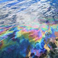
Oil company Taylor Energy Co LLC agreed to transfer a $432 million cleanup trust account to the U.S. government and pay an additional $43 million to resolve a lawsuit over its role in the longest-running oil spill in U.S. history under a proposed deal filed in New Orleans federal court on Wednesday.The New Orleans company and federal officials filed a proposed consent decree to resolve claims arising from a 2004 incident when Hurricane Ivan caused one of Taylor's offshore drilling platforms to collapse in the Gulf of Mexico.
NOAA helps ID prime Aquaculture Sites in GOM, off California

NOAA released two Atlases compiling the best available science to inform the identification of Aquaculture Opportunity Areas (AOAs) in the Gulf of Mexico and Southern California. NOAA previously identified these regions for their potential to host sustainable commercial aquaculture development in the United States. Areas in the Atlases will have characteristics expected to support multiple types of aquaculture industries including finfish, shellfish, seaweed, or some combination."The aquaculture Atlases apply the latest ocean data and information to advance sustainable business development…
ACBL to Pay Over $2 Million for Mississippi River Oil Spill
Jeffersonville, Ind.-based barging company American Commercial Barge Line (ACBL) has agreed to acquire and preserve 649 acres of woodland wildlife habitat and will pay an additional $2 million for damages stemming from a 2008 oil spill on the Mississippi River, near New Orleans.The company has already paid $1.32 million to reimburse the federal and state trustees for their past damage assessment and restoration planning costs after one of its barges discharged approximately 6,734 barrels (282,828 gallons) of No. 6 fuel oil into the Mississippi River upriver of New Orleans in July 2008.
Marine Economy Contributes Nearly $400 Billion to US GDP
America’s marine economy contributed about $397 billion to the nation’s gross domestic product in 2019 and grew faster than the nation’s economy as a whole, according to the most current results of the first official Marine Economy Satellite Account released today by two Department of Commerce agencies.“America’s strong marine economy is absolutely vital for building back better,” said Secretary of Commerce Gina M. Raimondo. “President Biden sees the immense value and potential of strengthening America’s blue economy…
NOAA Launches West Coast, Gulf of Mexico Coastal Models
NOAA on Wednesday announced two new coastal condition forecast models intended to help enhance decision making for mariners along the West Coast and Northern Gulf of Mexico. The models provide continuous quality-controlled data on water levels, currents, water temperature and salinity out to 72 hours.Forecasts from both models are used by commercial and recreational mariners, fisherman, emergency managers, search and rescue responders, and National Weather Service marine weather…
Sensor Systems Improve Marine Navigation Near US Naval Bases
Maritime navigational safety near two U.S. Navy installations in Kings Bay, Ga., and Portsmouth, N.H. has been improved thanks to new Physical Oceanographic Real-Time Systems, also known as PORTS, installed by NOAA and the U.S. Navy. They are the first new PORTS in two years, and the 34th and 35th in the nationwide network.The system near Naval Submarine Base Kings Bay, the East Coast home to America’s Ohio-class submarines, is an integrated series of sensors which will provide critical real-time information on oceanographic and meteorological conditions.
US' Marine Economy Growth Outpacing the Nation's
America’s marine economy, including goods and services, contributed about $373 billion to the nation’s gross domestic product in 2018 and grew faster than the nation’s economy as a whole, according to the marine economy statistics released today by two Department of Commerce agencies.“These statistics are the first-of-its-kind estimate of the U.S. marine economy, a primary driver of jobs, innovation and economic growth,” said retired Navy Rear Admiral Tim Gallaudet, Ph.D., assistant secretary of commerce for oceans and atmosphere and deputy NOAA administrator.
La Niña to Transition to Neutral Weather in April-May -U.S. Forecaster
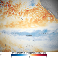
The La Niña weather pattern is likely to transition to ENSO-neutral conditions during the April-May period, a U.S. government weather forecaster said on Thursday. ENSO-neutral refers to those periods in which neither El Niño nor La Niña is present, according to CPC. There is a more than 50 percent chance of ENSO-neutral conditions prevailing through the northern hemisphere summer in 2018, the National Weather Service's Climate Prediction Center (CPC) said in its monthly forecast.
NOAA Releases Final Ocean Noise Strategy Roadmap
NOAA has released its final Ocean Noise Strategy Roadmap, which will guide the agency in more effectively and comprehensively managing ocean noise effects on marine life during the next decade. Sound is critical for the survival of many marine animals. It’s a primary means of communication, orientation and navigation, finding food, avoiding predators, and mate selection. Ocean noise can be caused by natural or human sources. The roadmap will serve as a guide across NOAA, reviewing the status of the science on ocean noise and informing next steps. NOAA is already taking on some of these recommendations, such as the recent launch of an underwater network of acoustic monitoring sensors.
Cuba, US Sign Memorandum on Maritime Navigation
Representatives of Cuba and the United States signed in Havana a memorandum of understanding (MoU) on cooperation in areas of hydrography and geodesy to improve the safety of maritime navigation. Ambassador Jeffrey DeLaurentis, the Chief of Mission at the U.S. Embassy in Havana, and Col. Candido Alfredo Regalado Gomez, Chief of Cuba’s National Office of Hydrography and Geodesy (ONHG), have signed the MoU. “NOAA (National Oceanic and Atmospheric Administration) has a strong interest in both improving navigational safety and in protecting the marine environment in the heavily travelled and vibrant waters between our two countries in the Straits of Florida,” said Russell Callender, Ph.D., assistant NOAA administrator for the National Ocean Service.
Living Shorelines Blunt Effects of Climate Change, Says NOAA
A recent NOAA study, published in the journal PLOS One, shows “living shorelines” — protected and stabilized shorelines using natural materials such as plants, sand, and rock — can help to keep carbon out of the atmosphere, helping to blunt the effects of climate change. This study, the first of its kind, measured carbon storing, or “carbon sequestration,” in the coastal wetlands and the narrow, fringing marshes of living shorelines in North Carolina. “Shoreline management techniques like this can help reduce carbon dioxide in the atmosphere while increasing coastal resilience,” said Russell Callender, Ph.D., acting director of NOAA’s National Ocean Service. Carbon can be stored or “sequestered” in plants when they take carbon dioxide from the atmosphere during photosynthesis.
Large Dead Zone Found in Gulf of Mexico
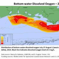
Mapped size confirms NOAA forecast for an average-sized hypoxia zone this year. NOAA- and EPA-supported scientists have mapped the Gulf of Mexico dead zone, an area with low oxygen water, measuring 5,052 square miles this summer--approximately the size of the state of Connecticut. The measurements were taken during the 30th annual hypoxia survey cruise from July 27 to August 2. This area falls within the predicted range of 4,633 to 5,708 square miles forecast by a suite of NOAA-sponsored models…
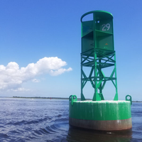
NOAA Offers a New Way to See Currents
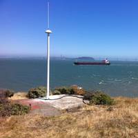
A new NOAA National Ocean Service website will provide mariners near real-time coastal ocean surface current observations and tidal current predictions in coastal waters using high frequency (HF) radar, making marine navigation safer for mariners and commercial shippers. The web-based observations are now available for the Chesapeake and San Francisco Bays in areas vital for marine navigation, with additional locations to follow. The product was made possible by NOAA’s Center for Operational Oceanographic Products and Services (CO-OPS) using data from the NOAA-led U.S.
US Hearing to Review Arctic Policy

The Subcommittee on Coast Guard and Maritime Transportation, chaired by Rep. Duncan Hunter (R-CA), will hold a hearing next week to review U.S. policy in the Arctic and how the agencies with the largest presence in the Arctic intend to implement such policy. It is declared U.S. policy, relative to the Arctic region, to meet national security and homeland security needs, protect the environment, ensure sustainable natural resource management and development, strengthen institutions for cooperation among Arctic nations…
Jacksonville Adds PORTS Real-time Data System
Officials from NOAA, the Jacksonville Marine Transportation Exchange, and the Jacksonville Port Authority officially dedicated a new information system today which will increase safety for ships using the St. Johns River. The system, called Physical Oceanographic Real-Time System (PORTS), provides real-time information on water levels, currents, meteorological conditions, and under-bridge clearance, giving users critical information when traveling through the river. The St. Johns River in Jacksonville will become the 23rd location to use the system and is the second largest PORTS ever established. “Our nation’s ports are critical cogs in our country’s economic engine,” said Kathryn D. Sullivan, Ph.D., under secretary of commerce for oceans and atmosphere and NOAA administrator.


