Coast Survey Improves Access to Wrecks Data
Knowing the locations of shipwrecks and other obstructions has always been important for safe navigation ‒ but mariners are not the only people who want to know about wrecks. They are also important for marine archeology, recreational diving, salvage operations, and fishing, among other interests. Now, Coast Survey has improved our Wrecks and Obstructions Database, giving everyone easy access to new records to explore.
Historically, Coast Survey has maintained two separate sources of information on wrecks. We recently combined the sources, bringing together information on nearly 20,000 wrecks and obstructions.
AWOIS
Coast Survey established the Automated Wreck and Obstruction Information System (AWOIS) database in 1981 to help estimate the level of effort required to investigate items during a planned hydrographic survey, but maritime users were also interested in AWOIS’ historical records. However, because the emphasis is on features that are most likely to pose a hazard to navigation, AWOIS has always had limitations. Most notably, AWOIS is not a comprehensive record and does not completely address every known or reported wreck. Additionally, for a number of reasons, AWOIS positions do not always agree with a charted position for a similar feature.
NOAA ENC
Coast Survey compiles NOAA’s electronic navigational charts (NOAA ENC®) from sources on features that are navigationally significant. As the official chart data used in electronic chart and display information systems (ECDIS), ENCs are the authoritative source of information about known or reported wrecks and are much more comprehensive than AWOIS. However, the features in an ENC typically lack the historic information and context provided by AWOIS.
Combined Data
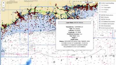
Correcting for some overlap between the two source databases, Coast Survey’s new wrecks and obstructions database now contains information on about 13,000 wreck features and 6,000 obstructions. Wreck features from each original database are stored in separate layers but can be displayed together. Users may also choose a background map from several options.
The new database also offers users additional data formats from which to choose. Historically, shipwreck data in AWOIS was available in Adobe PDF and as Microsoft Access Database (MDB) format. More recently, KML/KMZ files replaced PDF and MDB formats, making it easier for public users to view AWOIS data, by using freely available software such as Google Maps or Google Earth. Now, in addition to KML/KMZ and Microsoft Excel formats for general users, Coast Survey provides the data in ArcGIS REST services and OGC WMS services, for use in GIS software programs or web-based map mashup sites.


