

LEO Satellite Networks: Supporting Maritime Safety, Efficiency and Innovation

Across the maritime sector, the availability of data has never been higher. Supported by new data collection technologies and advanced analytics, mariners are gaining access to increasingly detailed information on the marine environment. Smart sensors are also becoming more widespread, enabling real-time monitoring of on-board equipment and cargo. Combined, these insights have the potential to provide both mariners and shore-based teams with greater situational and operational awareness throughout voyages.However…
UKHO Partners with Shom to Launch International S-100 Sea Trials Program

The UK Hydrographic Office (UKHO) has launched an international sea trials program in partnership with the French Hydrographic and Oceanographic Service (Shom). The joint program represents the most comprehensive test of S-100 data standards to date and will form part of the International Hydrographic Organization’s (IHO) coordinated test bed framework. Throughout the trials, the UKHO and Shom will collect evidence to inform safety and efficiency use cases, while providing guidance on the introduction of the S-100 data framework, which is set to underpin the future of maritime navigation.
Phase 1 of S-100 Implementation Complete
Phase 1 of S-100 Standards implementation is now complete after the operational release of standards S-124 Navigational Warnings and S-128 Catalogue of Nautical Products.The S-100 framework is a new global standard created by the International Hydrographic Organization (IHO), in collaboration with other hydrographic offices around the world, that enables the integration of diverse datasets within a single Electronic Chart Display and Information System (ECDIS) or other hydrographic…
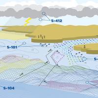
S-100 has Value Beyond ECDIS

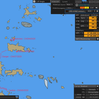
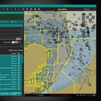
The S-100 framework is a new global standard created by the International Hydrographic Organization (IHO), in collaboration with other hydrographic offices around the world, that enables the integration of diverse datasets within a single Electronic Chart Display and Information System (ECDIS).Mariners will be able to combine various data layers with Electronic Navigational Charts including detailed depth information and dynamic information on tides and currents.S-100 builds on the digital foundation of S-57, the standard for electronic navigational charts since 1992.
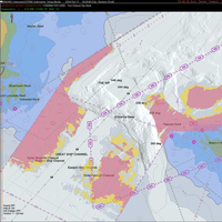
Canada Trials S-100 on St. Lawrence River
The Canadian Hydrographic Service (CHS), under Fisheries and Oceans Canada, is taking a leading role in validating new digital hydrographic standards, with the Minister of Fisheries, Joanne Thompson, launching S-100 sea trials on the St. Lawrence River.The S-100 data model is a new global standard created by the International Hydrographic Organization (IHO), which offers a new way of visualizing the marine environment using layered, interactive digital data that can be added to navigational charts.
Visual Estimate of Height Led to Crane Hitting Bridge
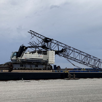
A captain and barge company managers not identifying the crane they were towing was too high to pass under the Mackinac Bridge near Mackinaw City, Michigan, led to the crane hitting the bridge, the US National Transportation Safety Board (NTSB) has concluded.On May 7, 2023, the towing vessel Nickelena was transiting the Straits of Mackinac, while towing a deck barge transporting a crawler crane, when the crane boom struck the main span of the Mackinac Bridge. The contact bent the crane boom backwards…
IHO Member States Adopt S-100 Operational Standards
International Hydrographic Organization (IHO) member states have adopted the first set of operational standards within the S-100 framework.The S-100 framework enables the integration of diverse datasets within a single Electronic Chart Display and Information System (ECDIS). Mariners will now be able to combine various data layers such as Electronic Navigational Charts (ENCs), detailed depth information and dynamic information on water level and currents to enhance situational…
Singapore Trials IHO S-100 Aboard Italian Navy Training Ship
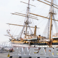
The International Hydrographic Organization - Singapore Innovation and Technology Laboratory (IHO-Singapore Lab) is conducting trials of next generation IHO S-100 standards and dual format Electronic Navigational Charts (ENCs) on a prototype S-100 ECDIS [2] aboard the Italian Navy's training ship, Amerigo Vespucci.This is known as the “dual fuel” mode within the international hydrographic community, where S-100 ECDIS supports both current S-57 and new S-101 ENC formats.This trial marks the first time that the dual format mode is used for navigation in the Malacca and Singapore Straits.
“K” Line Taps Navtor for Fleet Monitoring

Kawasaki Kisen Kaisha, Ltd. (“K” Line) has adopted NavFleet as a fleet monitoring system platform provided by Navtor A.S., and witnessed by Norwegian Embassy in Japan, “K” Line signed a MoU with Navtor regarding the development of “K” Line 24/7/365 global fleet monitoring and support system through the use and functional expansion of NavFleet on August 25.Navtor is Norway-based company developing the maritime DX business that is well known as a provider of electronic navigational charts…
Teledyne Acquires ChartWorld International

Teledyne Technologies Incorporated announced today that it has acquired ChartWorld International Limited and affiliates. ChartWorld, headquartered in Cyprus, with additional locations in Hamburg, Singapore, Vancouver and Tokyo, is a provider of digital marine navigation hardware and software provided through a subscription-based model. Terms of the transactions were not disclosed.Commercial maritime subscribers to ChartWorld’s software as a service (SaaS) receive free type-approved Electronic Chart Display and Information Systems (ECDIS), a lifetime warranty and global 24/7 support.
Arctic Shipping Requires New Ways to Manage Risks

In February 2021, LNG carrier Christophe de Margerie, escorted by a nuclear icebreaker, became the first large-capacity cargo vessel to transit the eastern sector of the Northern Sea Route (NSR). The voyage demonstrated that year-round safe navigation is possible along the entire length of the Northern Sea Route (NSR).In the last five years, cargo traffic along the NSR has grown almost fivefold, reaching 33 million tons in 2020. Last year, there were 64 voyages on the NSR compared with 37 in 2019.
Electronic Navigational Charts: An Update and Some Issues
In November 2019, the Office of Coast Survey (OCS), part of the National Oceanic and Atmospheric Administration (NOAA), announced the start of a five-year program to “sunset” all raster and paper nautical charts.NOAA has produced electronic navigational charts (ENCs) since 1993. In the 2019 notice, NOAA writes that “ENC sales increased 425% since 2008, while sales of paper charts are now half of 2008 levels.”For NOAA and mariners, a focus on electronic charts and publications promises many advantages. With a singular focus, NOAA can use its resources more efficiently.
NOAA Continues Transition to Electronic Navigational Charts
NOAA is continuing with the sunset plan for paper and raster nautical charts in August and September. A set of 15 charts covering the eastern half of the North Slope of Alaska will be moved into last edition status on August 5, 2021 and will be canceled on February 2, 2022. Another set of 14 charts covering the western half of the North Slope will be moved into last edition status on September 2, 2021 and be cancelled on March 2, 2022.This set of charts has been fully supplanted by new electronic charts as part of NOAA’s Office of Coast Survey Raster Sunset Plan…
OCIMF Publishes ECDIS Safety Recommendations
A new paper published by the Oil Companies International Marine Forum (OCIMF) on Wednesday provides guidance to enhance policies and procedures regarding the safe use of electronic chart display and information systems (ECDIS).With more vessels using electronic navigational charts (ENCs) for primary or secondary navigation, there have been several significant navigational incidents over the last decade where one of the contributing factors has been ECDIS-related, the U.K.-based safety association said.The new paper…
ChartWorld, JRC Team on Information Overlays
ChartWorld are JRC are cooperating on the addition of ChartWorld’s Information Overlay service, known as CIO+ onto JRC ECDIS. CIO+ is a data overlay shown in ECDIS as a user chart, loaded on top of Electronic Navigational Charts. CIO+ is a tool to help the Bridge team with the task of developing and executing efficient voyage plans by automating the process of applying additional data in ECDIS by means of User Chart objects.CIO+ is currently available for JRC ECDIS 9201 for both…
India, Mauritius in Joint Hydrographic Survey
The Government of Mauritius has organized an event at Port Louis to mark the successful completion of hydrographic survey by Indian Navy ship INS Darshak over the past one month.The aim of the survey was to publish navigational charts and electronic navigational charts of the region as part of the ongoing cooperation between the two nations.The function was attended by senior functionaries of the Government of Mauritius.Commanding Officer, INS Darshak Capt J Gurumani and Tanmay Lal, the High Commissioner of India to Republic of Mauritius handed over the preliminary hydrographic fair sheet of Souillac in southern Mauritius and Deep Sea Block of South-East of Mauritius to the Minister Louis Steven Obeegadoo…
ChartCo Launches Fixed Price PAYS Solution
ChartCo is expanding its OneOcean digital solution with its new ’Fixed Price Pay As You Sail’ (PAYS) system.The brand-new product will be launched on July 1, 2019ChartCo is expanding its OneOcean digital solution with its new ’Fixed Price Pay As You Sail’ (PAYS) system which is the first such system to allow budgetary certainty and global ENC data for planning and navigation purposes.Vessels using PAYS will be tracked and only charged for ENC permits according to the routes they actually sail.
Round the Clock Business Demands Seamless Comms
Network Innovations and its inland waterways connectivity solution eliminates “dead spot” coverage woes. And, not a moment too soon.The bane of inland operators – or at least one of many – has always been the dearth of reliable and economical vessel-to-shore communications. Even in America’s heartland where cellular coverage is routinely billed as seamless, so-called ‘dead spots’ persist. Sometimes, this happens at the worst possible moment for an operator who has myriad far flung assets on dozens of remote inland waterways. For a long time, satellite service has not been deemed economically feasible for inland operators. Beyond that, unlike blue water deep sea operators, there was little need to download data or employ software solutions in every day operations.
Singapore, Indonesia, Malaysia sign MOU for Joint Hydrographic Survey
To demonstrate multilateral cooperation between littoral states and stakeholders to improve navigational safety in the Straits of Malacca and Singapore (SOMS), Phase Two of a Joint Hydrographic Survey was formally launched via a Memorandum of Understanding (MOU) signed today at the 10th Co-operation Forum held from 2nd to 3rd October 2017 at Kota Kinabalu, Malaysia. Besides the littoral states, the survey is supported by the Malacca Strait Council (MSC) of Japan. Phase Two, which is a continuation from Phase One, will cover the remaining areas of the Traffic Separation Scheme (TSS) within the SOMS which are shallower than 30m. The data obtained from the survey would be used to produce up-to-date…
NAVTOR Opens US Office

E-navigation specialist NAVTOR said it has set its sights on the U.S. shipping market with a new office opening in Seattle. The Norwegian business, which has built a global network of facilities since forming in 2011, has, until now, serviced the territory from its Egersund headquarters. However, growing demand Stateside for the firm’s product portfolio has prompted the team to establish NAVTOR USA Inc. NAVTOR launched its ENC service to market in 2012 and, since then, has built a global client base on the back of its mission of making life simpler for navigators…
Inmarsat Provides Pacific Northwest, Bering Sea Coverage for Dunlap
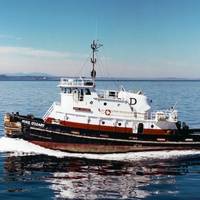
Mobile satellite communications company Inmarsat said it has partnered with satellite communications provider Network Innovations and maritime transportation provider Dunlap Towing to install Fleet One across its fleet of 12 vessels. For Dunlap, the Dutch Harbor and Pacific Coast routes in Alaskan waters have traditionally been challenging and its existing service did not offer the reliability required to transmit important operating and safety reports, communicate back to shore or make critical inter-fleet voice calls, according to Inmarsat.
Royal Caribbean to Install NavBox Across Entire Fleet
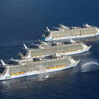
Royal Caribbean Cruises Ltd (RCC) has signed a deal with NAVTOR to install the NavBox navigation solution across its entire corporate fleet of 49 vessels, in a deal which spans RCC's six different operating companies. E-navigation specialist NAVTOR launched NavBox in 2013. The solution, which complements NAVTOR’s range of electronic navigational chart (ENC) based services, automatically downloads, distributes and updates all vessel navigational charts and publications, cutting administration time, while ensuring the very latest, compliant charts are always at hand.
Danelec Unveils New ECDIS at SMM
Danelec Marine is rolling out its new DM700 series Electronic Chart Display and Information System (ECDIS) for marine navigation at the SMM maritime trade fair in Hamburg, Germany, held from September 6-9. The DM700 ECDIS provides a basic ECDIS solution that fully complies with the new IEC and IHO performance standards which will be mandatory in all ECDIS ship installations beginning August 2017. Danelec Marine introduced its new-generation DM800 ECDIS in 2015. With the addition of the new DM700…


