

SevenCs Launches Nautilus ChartServer Chart Rendering Engine

SevenCs GmbH, a provider of maritime charting solutions, announced the release of Nautilus ChartServer, its chart rendering engine designed to meet the evolving demands of maritime, defense, and autonomous navigation applications.Building on the WMS ChartServer, Nautilus ChartServer introduces a modern, scalable architecture that is fully S-100-ready, supporting current standards such as S-57, S-101 ENC, IENC, AML, and future S-102 bathymetric surfaces, while paving the way for future S-100-based products.Benefits of the Nautilus ChartServer include:S-100 Ready: Supports S-57, S-101, IENC, AML
Teledyne Acquires ChartWorld International

Teledyne Technologies Incorporated announced today that it has acquired ChartWorld International Limited and affiliates. ChartWorld, headquartered in Cyprus, with additional locations in Hamburg, Singapore, Vancouver and Tokyo, is a provider of digital marine navigation hardware and software provided through a subscription-based model. Terms of the transactions were not disclosed.Commercial maritime subscribers to ChartWorld’s software as a service (SaaS) receive free type-approved Electronic Chart Display and Information Systems (ECDIS), a lifetime warranty and global 24/7 support.
ChartWorld Suspends Services to Russian Vessels and Companies
Following the Russian invasion of Ukraine, ChartWorld has announced the suspension of ECDIS, chart, and navigation data services to Russian-owned and managed vessels. Current vessels will be provided with chart updates to allow them to reach the next port safely but have been asked to find new suppliers for all future voyages. The group's other companies, including navigation and ENC software development company SevenCs, have also suspended all projects and software deliveries to Russian companies and vessels.Steven Schootbrugge…
SevenCs Releases ORCA Pilot X Software
SevenCs, part of the ChartWorld Group, announced the release of ORCA Pilot X software. Originally designed as a primary navigation aid for Pilots, ORCA Pilot X is a tool for professional navigators. ORCA Pilot X is being offered as a free download on the Apple AppStore for iOS tablets.SevenCs has a long tradition of developing bespoke navigation applications for pilots around the world. Following the feedback and input from many users, SevenCs began the development of ORCA Pilot X as the natural evolution from ORCA Pilot G2.Ralf Lehnert…
SevenCs Upgrades Chart Validation Tool
SevenCs has released a new version of the chart validation tool, 7Cs Analyzer. 7Cs Analyzer Version 4.2. comes with new features to make chart validation more flexible and customizable.Shape File ExportMost chart production tools have a built-in shape file reader. Therefore, we have included a new module in Version 4.2. It gives users the opportunity to save the validation log file in ESRI shape file format. The shape files contain the features that require attention as well as the associated validation messages.
SevenCs Updates WMS ChartServer
SevenCs has released WMS ChartServer, version 5, which provides enhanced functionality across several fronts.Greater interoperability is the key to WMS ChartServer’s support of spatial queries; this support takes the depth and relevance of information on offer to a new level, using GeoJSON-formatted coordinates.Interoperability and valuable context were also the benefits fueling the development of bounding boxes that cover more than 360° of latitude. These give customers compatibility…
Introducing 7Cs Analyzer
For more than 20 years, numerous digital chart producers (Hydrographic Offices, Waterway Authorities, and other organizations) have used SevenCs validation tools for quality control and quality assessment of digital charts such as ENCs, IENCs, and AMLs against the relevant standards.At SevenCs, we have been working hard to improve our validation solutions and now the new 7Cs Analyzer Version 4.0 is available. The new Analyzer is based on SevenCs latest S-100 Kernel technology and provides the most comprehensive validation tool on the market.
Top Speed For Your Maritime Charts
SevenCs has just released a brand new software tool called TMS ChartServer which is running on a high performance “Tile Map Service” technology. It allows users of maritime web and mobile applications – e.g. Fleet Monitoring, Vessel Tracking, and Surveying – to display maritime charts at top speed: no matter if full global chart coverage is needed or just a smaller area of interest. SevenCs GmbH is located in Hamburg, and for decades has been “the Expert” in developing maritime software applications.
ORCA Pilot Chart Mapper: Pilot Chart within Seconds
ORCA Pilot Chart Mapper is a new tool for SevenCs PPU software, ORCA Pilot G2. The product is developed to make Pilots more independent, flexible and up to date, when it comes to high precision charts in local areas. Chart Mapper is a tool to create an optional chart layer with high density depth information for display in a PPU within seconds. ORCA Pilot Chart Mapper reads xyz point cloud data and processes it to create S-57 high density bathymetry layers – e.g. bathymetric ENCs.
SevenCs Supports MariGreen Project
SevenCs is part of the EU INTERREG V A cross-border project “MariGreen” to support the maritime industry in the transition towards more efficient, greener and more sustainable shipping. The MariGreen project develops innovations for greener and low-emission shipping and supports in particular small and medium enterprises. There are 12 innovation projects behind "MariGreen" that are dealt with by a total of 59 partners located in the Netherlands and Germany. Alternative fuel for ships, Wind Energy Systems for freight and passenger shipping, improvement of logistics operations, resource-efficient ship operations and safety issues in nautical education and training are among the main topics. SevenCs engages in the MariGreen work stream “Wind propulsion in commercial shipping”.
First Type Approval Awarded for Portable Pilot Unit
DNV GL said it has developed a new industry standard for the type approval of Portable Pilot Units (PPUs); the ORCA Pilot G2 unit, created by SevenCs, a navigation equipment and software expert from Hamburg, is the first product worldwide to achieve compliance with the new standard. “In summer 2015, we developed the Type Approval for PPUs, in order to allow ports, terminal operators and pilot organisations to assure a minimum standard in the selection process of their equipment, against which manufacturers of navigation equipment can test their products.
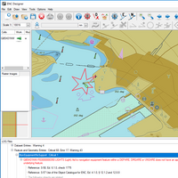
SevenCs Launches New ECDIS Kernel
The new version of the SevenCs ECDIS Kernel SDK (Software Development Kit) 5.20 has been designed to meet all future requirements of the latest international standards to reduce implementation irregularities and improve the overall usability of chart display systems (IEC 61174 Standard edition 4.0; IHO S-52 Presentation Library edition 4.0; IHO S-64 Test Standard edition 3.0). Eric Rottman, Kernel SDK product manager, commented, “A major focus of the release version 5.20 has been laid on detection and indication of danger and caution objects.
TU Varna Opens Maritime Simulator Wing

New simulator wing features DNV certified VSTEP Dynamic Positioning and Full Mission Bridge Simulators and type approved ECDIS classroom. The simulation center of the Technical University of Varna officially opened its new simulation wing on May 21, 2015, following the opening of its simulation center in 2012. All the simulators in the TU Varna training center are delivered and installed by VSTEP. The new wing features a NAUTIS Class B DP Simulator as well as a NAUTIS class A Full Mission Bridge Simulator and a new ECDIS Simulator classroom.
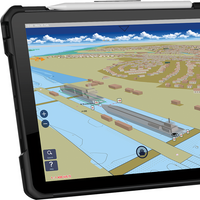
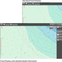
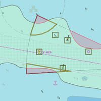
Portsmouth Pilots Use High Detailed Charts
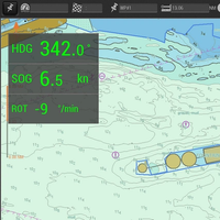
Portsmouth Pilots are now using bathymetric ENCs in combination with official ENCs on their Portable Pilot Units. For many years Portable Pilot Units (PPUs) with SevenCs pilot information systems have been successfully used by a large number of pilot organizations. As a result of this collaboration, SevenCs has developed a brand new system, called ORCA Pilot G2. It includes the typical functions of a navigation system for touchscreen operation, where own ship and AIS targets are displayed on a background of tailor-made electronic charts – dense bathymetric, port or large scale ENCs.
SevenCs Release ChartServer 4.3
SevenCs explains that ChartServer is a WMS server that enables the user to view nautical chart data (e.g. S-63 encrypted ENCs). S-63; ARCS; DNC; VMap; ARINC; DTED. It also includes the newly improved chart loading and installation tool - Chart Handler. ChartServer can be used in combination with or as a backdrop to other geo-spatial data layers (e.g. weather). It is specifically designed for performance oriented applications, generated to display chart data using web technology. ChartServer is developed in accordance with OGC requirements, making it the perfect tool for the integration with your application. Based in Hamburg, SevenCs develops S-57 chart display Kernels for ECDIS…
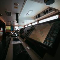
SevenCs to Unveil 'The Electronic Chart Table'
Inspired by more than 20 years of ECDIS experience and user feedback from officers all around the world, SevenCs says it is presenting “The Best of Two Worlds” – The Electronic Chart Table. Utilizing a touch screen varying from 46 to 75 inches, the crew on board can finally use an overview chart just as if it were the paper equivalent. Easy to use software, based on an ECDIS Kernel, allows detailed and compliant presentation of S-57 ENCs. The software was specifically designed for touch screen operation and has successfully been tested by navigators, captains and pilots worldwide. The prototype touch screen navigation software can be adapted in design, functions and features to meet exactly the particular client’s needs and integrate smoothly into a new bridge design.
SevenCs Debuts Aviation Module for ECDIS Kernel
The new 5.18 version of the EC 2007 software development kit (SDK) from SevenCs is available for both Windows and Linux applications, updated to now include support of Digital Terrain Elevation Data (DTED), ARINC 424 Aviation Charts and new development environment Visual Studio 2010 32/64bit. The EC2007 ECDIS Kernel assists OEMs to develop a wide range of marine chart display application, such as ECDIS, WECDIS, VTS, Inland ECDIS, ECS, PPU and tactical consoles. It includes more than 1,000 functions for chart display, chart handling and navigation.
UK's Portsmouth Pilots Choose SevenCs Navigational Tool
The providers of the system, SevenCs inform that after a series of trials with different Portable Pilot Units (PPU) the Portsmouth Pilots have selected ORCA Pilot G2 as their navigation tool of choice. The new software is produced by SevenCs, the leading maritime software development company for navigation and chart production. With Centerprise International as the local distributor for the UK, customers can rely on a strong partner with a proven track record for governmental and public service IT projects. Ben McInnes, Deputy Harbour Master and Portsmouth Pilot said: “The new software is easy to use and offers amazing capabilities. The SevenCs solution offers the pilot organization a maximum of freedom in selecting their preferred hardware and sensors.
Portsmouth Pilots Choose ORCA Pilot G2

After a series of trials with different Portable Pilot Units (PPU) the Portsmouth Pilots have selected ORCA Pilot G2 as their navigation tool. The new software is produced by SevenCs, the leading maritime software development company for navigation and chart production. With Centerprise International as the local distributor for the U.K., customers can rely on a strong partner with a proven track record for governmental and public service IT projects. Ben McInnes, Deputy Harbour Master and Portsmouth Pilot said, “The new software is easy to use and offers amazing capabilities.
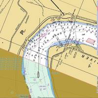
CEACT Allows Operators to REACT
How updated electronic navigation practices improve safety and efficiency – and optimize cargo movement – on US inland waterways. It was a cold winter night. Heavy gusts and snow did not allow safe navigation and forced the ships on the upper Mississippi to secure alongside the few remaining jetties. Safety is the key issue for all river transport companies but at the same time efficiency and timely delivery of valuable goods is of utmost importance. It was 1999 and an American navigation pioneer – Greg Dunkle – had realized the potential of electronic chart systems.
SevenCs Conducts Capacity Building for Montenegro

After signing a RENC membership agreement with the Institute of Hydrometeorology and Seismology Montenegro (IHMS) PRIMAR and the Norwegian Hydrographic Service team up with SevenCs for capacity building. In November 2013, IHMS signed a RENC agreement with PRIMAR. Having a motivated team, paper charts and some recent surveys, IHMS was lacking a production environment and detailed knowledge in ENC production. Funded by the Norwegian Hydrographic Service, PRIMAR was able to provide its latest member with a full ENC production environment plus training.
New CEACT Improves Safety and Performance
The upgraded CEACT aims to improve operational efficiency and situational awareness for safer navigation. The new CEACT version 2.6.10, available now, includes several improvements. According to the manufacturer, the new CEACT 2.6.10 introduces a modernized user interface for enhanced readability in all ambient conditions, and more user friendliness in general. It helps the river pilot to safely navigate and focus on the most relevant data which helps preventing accidents. Advanced…
SevenCs Win Peru ENC Encryption Contract
Peruvian Direción de Hidrografia y Navegación has chosen SevenCs' S-63 Encryption Software to encrypt Electronic Navigation Charts (ENC) S-57 data as recommended by the IHO S-63 data protection scheme. It is probably not widely known that ENCs are not excluded from copyright infringement and data piracy is a general problem of the digital area. The Peruvian DHN (Direción de Hidrografia y Navegación) as a publisher of official nautical information wanted to protect and authenticate their certified data according to the official security scheme. Commander Julio Behr Laca, head of the cartography department, comments:”Official Peruvian ENCs are distributed by IC-ENC.


