

Captain Steered Ship Straight onto Rock
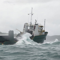
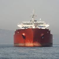
An anchor chain failure, followed by a navigation failure, led to the grounding of the cargo vessel Bonnie G in the Caribbean Sea, the National Transportation Safety Board (NTSB) has concluded.On October 4, 2023, the Bonnie G was anchored, waiting out poor weather about 1 mile south of St. Thomas, U.S. Virgin Islands, when its anchor chain parted and the vessel began to drift toward land.As the captain attempted to navigate the vessel away from shore, the vessel grounded.The 12 people on board abandoned the vessel and were rescued by the U.S. Coast Guard.
ClassNK Greenlights SHI’s Autonomous Navigation Assistance System
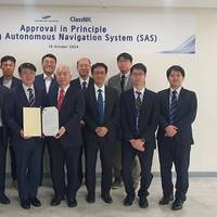
ClassNK has issued an Approval in Principle (AiP) for Autonomous Navigation Assistance System ‘SAS’ developed by Samsung Heavy Industries (SHI).Samsung Autonomous Navigation Assistance System (SAS) is partially Autonomous Navigation System (ANS) including the functions of situational awareness through sensor fusion and electronic navigational chart information, collision and grounding risk assessment, collision and grounding avoidance.ClassNK is involved in various demonstration projects and continuously works to develop necessary safety standards…
Voyage Optimization Plan Led to Grounding of Bulk Carrier
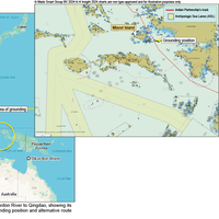
The UK Marine Accident Investigation Branch (MAIB) has released its preliminary assessment of the grounding of the bulk carrier Indian Partnership on April 23, 2023, and implicated voyage optimization planning.The UK-registered bulk carrier ran aground at 0409 off the coast of Misool Island while transiting the Indonesian archipelago. The grounding caused significant breaches to the hull, leading to water ingress into the duct keel and five ballast water tanks.Indian Partnership had set sail from Skardon River…
Chart Error Led to ATB Grounding in Alaska
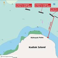
An articulated tug and barge (ATB) hit a known underwater rock near Kodiak, Alaska, last year, leading to a grounding that caused $1.4 million in damages, the National Transportation Safety Board (NTSB) said Tuesday.The Brice Marine-owned and -operated tugboat Cingluku and barge Jungjuk were transiting into Shakmanof Cove from Marmot Bay on May 25, 2023, with six crewmembers onboard. The Cingluku and Jungjuk operated together as an ATB, and were primarily used to transport containerized cargo and vehicles.
“K” LINE Chooses Navtor Fleet Monitoring System
Kawasaki Kisen Kaisha (“K” LINE) has chosen Navtor’s NavFleet solution to support its 24/7 global fleet monitoring and support system.Once operational, the facility will help the Japanese maritime logistics company enhance the safety, efficiency and sustainable performance of its inhouse managed fleet. NavFleet will seamlessly connect vessels, crews and onshore teams and provide real-time monitoring and operational insights.“NavFleet builds a bridge between ships and shore,” explains Tor A. Svanes, CEO Navtor.
Navigational Errors Caused Cruise Ship to Strike Pier in Alaska
Overreliance on an electronic chart, miscommunication and an outdated navigational chart were among factors that led to a cruise ship striking a pier last year near Sitka, Alaska, the National Transportation Safety Board (NTSB) said Tuesday.The Royal Caribbean cruise ship Radiance of the Seas was docking at the Sitka Sound Cruise Terminal on May 9, 2022, when it struck and damaged a mooring dolphin. The cruise ship sustained a minor hull indentation. The mooring dolphin sustained damage to three of the four pilings supporting it.
FarSounder, Navtor Partner
FarSounder and Navtor announces a new partnership, with FarSounder now including support for NAVTOR official ENC chart data in itsbase software package.Navtor is centered on creating e-Navigation tools that are safe, simple and efficient. Similarly, FarSounder’s Argos 3D Forward Looking Sonar is designed to provide safe navigation by detecting many ocean obstacles via an easy-to-understand user interface. According to the pair, this partnership will bring an impactful software update for Argos technology."By implementing the NavtorECDIS Kernel in the FarSounder platform…
Electronic Navigational Charts: An Update and Some Issues
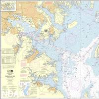
In November 2019, the Office of Coast Survey (OCS), part of the National Oceanic and Atmospheric Administration (NOAA), announced the start of a five-year program to “sunset” all raster and paper nautical charts.NOAA has produced electronic navigational charts (ENCs) since 1993. In the 2019 notice, NOAA writes that “ENC sales increased 425% since 2008, while sales of paper charts are now half of 2008 levels.”For NOAA and mariners, a focus on electronic charts and publications promises many advantages. With a singular focus, NOAA can use its resources more efficiently.
NOAA Begins Transition Exclusively to Electronic Navigation Charts
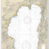
NOAA will begin to implement its sunset plan for paper nautical charts this month, starting with the current paper chart 18665 of Lake Tahoe. After August, NOAA’s electronic navigational chart will be the only NOAA nautical chart of the area.This is the first traditional paper chart to be fully supplanted by an electronic chart as part of NOAA’s Office of Coast Survey Raster Sunset Plan, which includes a new process to notify mariners of the transition of individual paper charts to electronic charts.
Autonomy on Trial
When discussing the arrival of autonomous workboats, many – especially those developing the technologies that enable them – say it’s is not a matter of if, but when. In fact, autonomous harbor tugs are already being put to the test in Singapore, where authorities hope to establish the technological infrastructure to enable fully autonomous ship operations. In the U.S., an autonomous vessel was shown to be able to respond to marine oil spills.But is autonomy really the future?
JIN Honors NYK for New Navigation Tool
Japanese shipping company Nippon Yusen (NYK) has been recognized with a special award from the Japan Institute of Navigation (JIN) for improving onboard operation through use of J-Marine NeCST, a ship navigation support tool that was jointly developed by NYK, MTI Co. Ltd., and Japan Radio Co. Ltd. (JRC).J-Marine NeCST (NeCST is pronounced “Next”) allows users to easily plan routes using the handwriting function of the electronic navigational chart, in addition to managing and sharing operational data using integrated information such as meteorological and hydrographical forecasts.An awards ceremony was held on July 12, 2019, and attended by Tomoyuki Koyama…
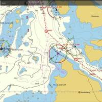
ECDIS & Maritime Accident Investigation

It’s not where you are, it’s where you should not be that mattersCaptain Whyte, a leading marine accident analyst at LOC Group, an independent marine and engineering consultancy which provides services to the shipping and offshore energy industries, explains how electronic data is making accident investigation clearer by providing irrefutable evidence.“Fundamentally, situational awareness underpins everything we do”, said Captain Whyte. “Whether that’s crossing the road or driving ships at sea. We need to know where we are, what we’re doing and where we are going.
USCG Navigation Center: Steering a steady course for safe, secure, efficient waterways

The U.S. Coast Guard’s Navigation Center (NAVCEN) is involved in a number of activities that have an impact on all Americans, even if they don’t realize it.From motorists checking directions with their Global Positioning System (GPS) to boaters to ships coming and going to U.S. ports, the NAVCEN plays an unseen but vital role.With a staff of19 officers, 17 enlisted personnel and 19 civilians, NAVCEN falls under the Director of Marine Transportation Systems (CG-5PW) at USCG Headquarters…
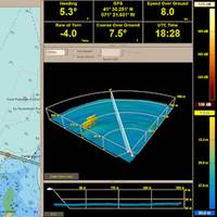
Rutter Releases Sigma S6 V9.2.0
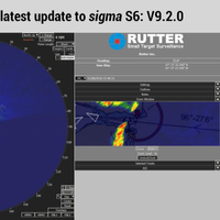
Rutter Inc. has released the latest update to the Rutter sigma S6 product line, version 9.2.0. This new version is being released for general availability this week. It is also available as an upgrade on existing systems for qualifying customers.Rutter’s proprietary radar data processing system interprets data from both conventional marine navigational and coastal surveillance radars, providing enhanced radar imagery and state of the art detection, tracking, and measurement capabilities.
ChartCo Introduces EnviroManager 5.4 At Europort
ChartCo introduced version 5.4 of its EnviroManager. Already installed on over 500 vessels since its launch in early 2017, EnviroManager consolidates information to assist vessels to comply with MARPOL regulations for discharges and emissions. EnviroManager includes the baseline information for each nation as required by regulations. The display shows “distance from land” as measured from the official country baseline, as opposed to the shoreline which is identified on a navigational chart.
Most Cargo Ships Over 20,000 GT are ECDIS Ready -UKHO
Almost three-quarters of cargo ships over 20,000 gross tonnage (GT) are already compliant with the SOLAS-mandated Electronic Chart Display and Information System (ECDIS) deadline of July 1, 2017, according to the latest figures published by the United Kingdom Hydrographic Office (UKHO). The UKHO estimates that a further 3,828 cargo ships over 20,000 GT are yet to make the transition to using an ENC (Electronic Navigational Chart) service and therefore do not yet meet SOLAS (Safety of Life at Sea) regulations on ECDIS carriage.
Royal Caribbean to Install NavBox Across Entire Fleet
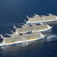
Royal Caribbean Cruises Ltd (RCC) has signed a deal with NAVTOR to install the NavBox navigation solution across its entire corporate fleet of 49 vessels, in a deal which spans RCC's six different operating companies. E-navigation specialist NAVTOR launched NavBox in 2013. The solution, which complements NAVTOR’s range of electronic navigational chart (ENC) based services, automatically downloads, distributes and updates all vessel navigational charts and publications, cutting administration time, while ensuring the very latest, compliant charts are always at hand.
NaviPlanner: A New Formula for Voyage Planning
Aiming to change the way mariners manage back of bridge systems, Nautisk has developed NaviPlanner, an integrated end-to-end voyage planning solution which utilizes touch-screen functionality and uses cloud technology based on the Microsoft Azure platform. Head of Nautisk’s product development and technical team Kjetil Bentsen said, “NaviPlanner is designed to make the operational task of planning and managing voyages a simpler, more effective process, from start to finish. Using compliant navigational chart data and digital publications…
GAC SMHI Weather Solutions for Safer, Efficient Shipping
Forecasts and route planning tools from GAC-SMHI Weather Solutions are playing a key role in a European Union initiative to promote safer and more efficient shipping. The Sea Traffic Management (STM) Validation Project, developed by a European Consortium led by the Swedish Maritime Administration, aims to make merchant shipping safer, smoother and more efficient by tackling the fact that international shipping remains relatively unregulated. The route chosen by a ship is often unknown to other vessels – something which can increase the chances of collisions, near misses, congestion and delays. The STM projects aims to tackle that issue by exploring ways in which routing information and planning can be shared to minimise the risks.
ECDIS Related Detentions on the Rise
ClassNK has been informed by Australian Maritime Safety Authority (AMSA) that during PSC inspections it has been increasingly reported that vessels have been detained because PSCO considers a deficiency regarding ECDIS means evidence of insufficient ISM performance of the vessel. Eight detentions for such grounds had been reported from January 2016 to May 2016, which was double the number of such detentions reported in the latter half of 2015. AMSA has released Marine Notice 8/2016 about the proper operations of ECDIS. (The URL and contents of the Notice are described at the end of this Bulletin). Moreover, there have also been reports that AMSA is carrying out inspections of ECDIS as a priority item.
Majority of Global SOLAS Fleet is ECDIS Ready
The majority of the global SOLAS fleet is now compliant with the SOLAS regulations on ECDIS carriage, according to the latest data published by the United Kingdom Hydrographic Office (UKHO) at Posidonia. As of May 2016, 51 percent of all vessels that are subject to the SOLAS regulations on the mandatory carriage of ECDIS, including those that do not trade internationally, are now fully ECDIS ready. This is an increase of 6 percent in the past six months. Furthermore, out of almost 42,000 internationally trading vessels, the UKHO now estimates that 59 percent are ECDIS ready, which is defined as using an ENC (Electronic Navigational Chart) service on ECDIS.
Cuba, US Sign Memorandum on Maritime Navigation
Representatives of Cuba and the United States signed in Havana a memorandum of understanding (MoU) on cooperation in areas of hydrography and geodesy to improve the safety of maritime navigation. Ambassador Jeffrey DeLaurentis, the Chief of Mission at the U.S. Embassy in Havana, and Col. Candido Alfredo Regalado Gomez, Chief of Cuba’s National Office of Hydrography and Geodesy (ONHG), have signed the MoU. “NOAA (National Oceanic and Atmospheric Administration) has a strong interest in both improving navigational safety and in protecting the marine environment in the heavily travelled and vibrant waters between our two countries in the Straits of Florida,” said Russell Callender, Ph.D., assistant NOAA administrator for the National Ocean Service.
Chart Tile Service to Aid Charts Update
NOAA Coast Survey gives commercial navigation systems better tool to receive updated nautical charts. Accessing up-to-date nautical charts on electronic systems and mobile apps is about to get easier, as developers start adopting NOAA Coast Survey's new Chart Tile Service prototype. Navigational chart users should not notice any difference in how their charting systems operate - except that service providers will be able to quickly update the charts with hundreds of corrections applied weekly by NOAA, so users will have the corrected versions faster than ever before. Coast Survey released the NOAA prototype chart tile and metadata service on December 7.


